Azores Itinerary- How to Spend 3 Weeks in the Azores
Purchases made through links earn us a small commission, at no extra cost to you.
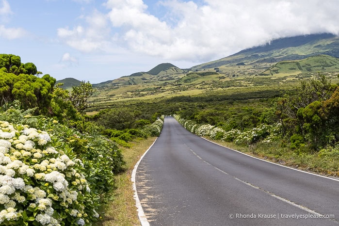
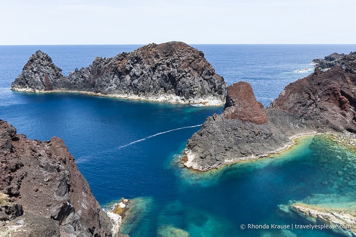
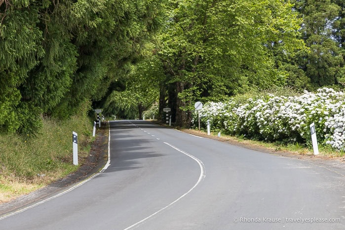
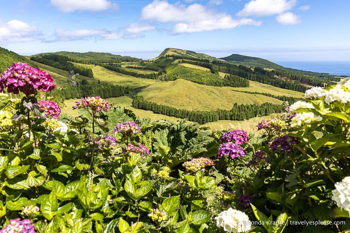
A trip to the Azores shot to the top of my bucket list after I first saw a photograph of one of its lake-filled calderas. Intrigued, I looked for more photos and was soon captivated by waterfalls streaming down a lush cliffside, a volcanic chimney covered in plants, hydrangea-lined roads, and a volcano with a cone on the edge of its crater. It looked like my idea of paradise!
Having now spent 3 weeks in the Azores, I can say that it truly is a nature lover’s dream! This Portuguese archipelago in the North Atlantic Ocean had everything I love- exquisite landscapes, interesting hikes, and a feeling of being undiscovered. It was a place that filled me with joy and left me in disbelief, exclaiming out loud to myself as I admired the views, “How is this even real?” and “How am I the only one here?”
My Azores island-hopping adventure will always be special to me because of the experiences I had, the places I saw, and the phase of my life I took this trip. While writing my Azores itinerary to share here, I felt so much gratitude, but also sadness that my trip is over.
I’m excited to share my 3 week Azores itinerary, my reflections about each island, and some tips for planning a trip to the Azores as an independent traveller. I hope it gives you an idea of all the wonderful things to do and places to visit in the Azores!
Three Weeks in the Azores- My Azores Itinerary
When I started planning my Azores trip, I knew it wasn’t going to be a short one. There were just too many pretty places to see!
I wasn’t initially intending to spend 3 weeks in the Azores, but trying to narrow down my list of places that interested me was stressing me out. So I decided to go big and try to see everything I wanted in one trip, with enough time not to be rushed and some flexibility for bad weather.
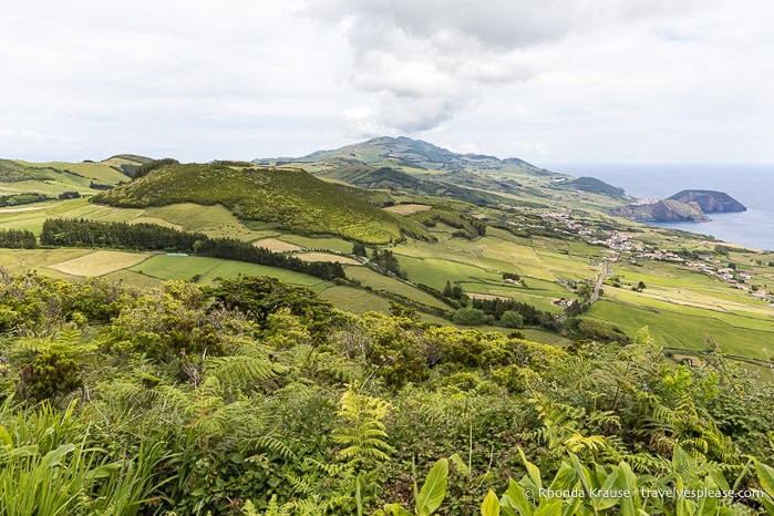
My Azores itinerary included 8 of the 9 islands- Flores, Corvo, Faial, Pico, São Jorge, Graciosa, Terceira, and São Miguel. I didn’t visit Santa Maria because it’s known for beaches and I get bored at beaches.
My Azores trip itinerary focused on experiencing the archipelago’s natural beauty. I went on hikes, swam at waterfalls, explored caves, admired calderas and crater lakes, soaked in hot springs, and visited scenic viewpoints. There were a couple of museums I visited, but the majority of my trip was spent outdoors.
It wouldn’t have been possible to do this Azores itinerary without renting cars. Bus service is limited, catering to locals rather than tourists, and guided tours see only the highlights while sticking to a strict schedule. A rental car gave me the freedom and flexibility I value as an independent traveller, so there was no limit on where I could go or when.
As for transportation between the islands, sometimes I took a plane and sometimes I took a ferry. The travel times were short- only two journeys were longer than an hour and nothing was longer than 90 minutes.
Even though I planned what I thought was the perfect Azores itinerary, based on my interests and logistics, in actuality, my days turned out differently because of the weather. Low-hanging fog prevented me from seeing some of my must-visit sites and forced me to stray from my “ideal” plan.
To help you plan your own Azores trip, here’s my island-hopping itinerary with some of the best places to visit in the Azores.
Flores Island
3.5 days, 3 nights
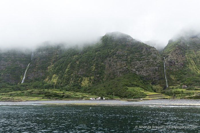
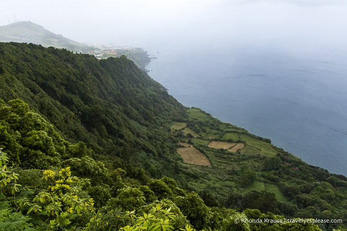
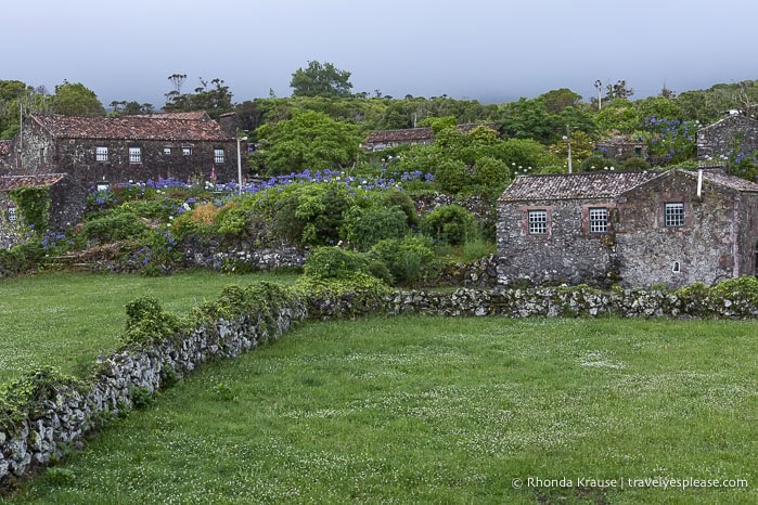
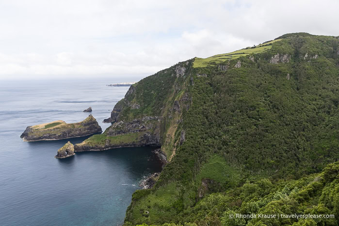
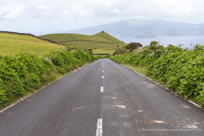
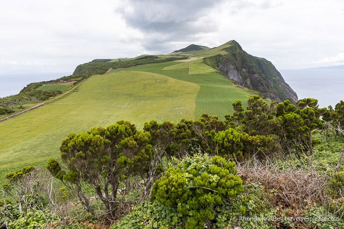
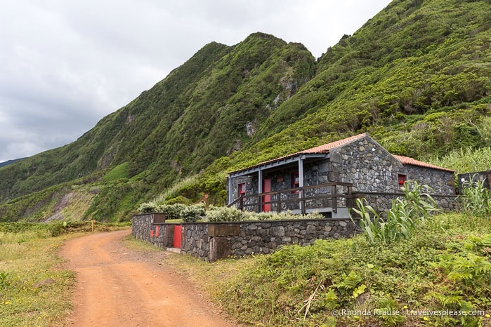
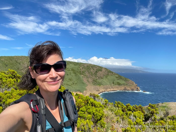
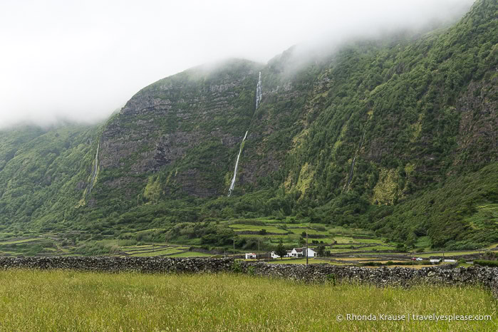
Flores was the island I was most looking forward to because of its waterfalls, crater lakes, cliffs, geological formations, and lush vegetation.
Unfortunately, I didn’t see most of what I went there for since the top of the island was constantly covered by clouds and the thickest fog I’ve ever experienced. I spent most of my time driving around trying to catch a break in the fog, revisiting places hoping for a better view, and admiring scenery at lower elevations. Even though the weather was a heartbreaking disappointment, Flores Island was still my favourite.
Overnights: Santa Cruz das Flores
Day 1 (PM): Visit Viewpoints on the Southeast Coast
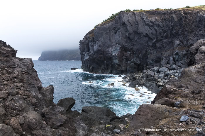
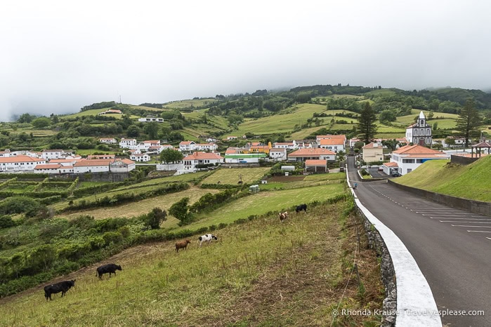
It was late afternoon by the time I arrived in Santa Cruz das Flores and got my rental car, so I didn’t have much time before calling it a day. I decided to drive along the ER1-2 on the southeast coast to visit some viewpoints. I drove as far as Rocha dos Frades, the island’s most distinctive rock formation, but it was completely hidden by fog.
Miradouro da Caldeira
At the parish of Fazenda das Lages, I stopped at Miradouro da Caldeira. This viewpoint had green fields sloping down towards the coast, but it was less impressive than I expected based on the name. My favourite part was the view from the parking lot of the parish and its church backed by hills.
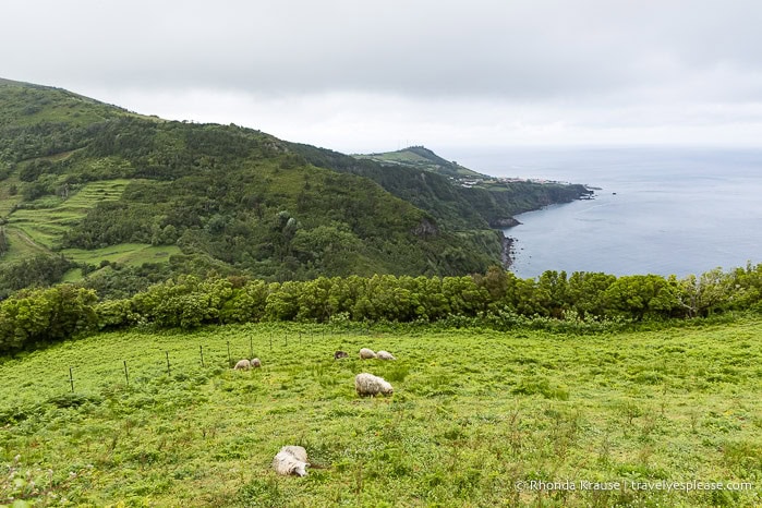
Miradouro da Caveira
Miradouro da Caveira offers views of green hills and seaside cliffs to the north. There were even some sheep in a field. It was a nice view, but not spectacular.
Miradouro da Fajã do Conde
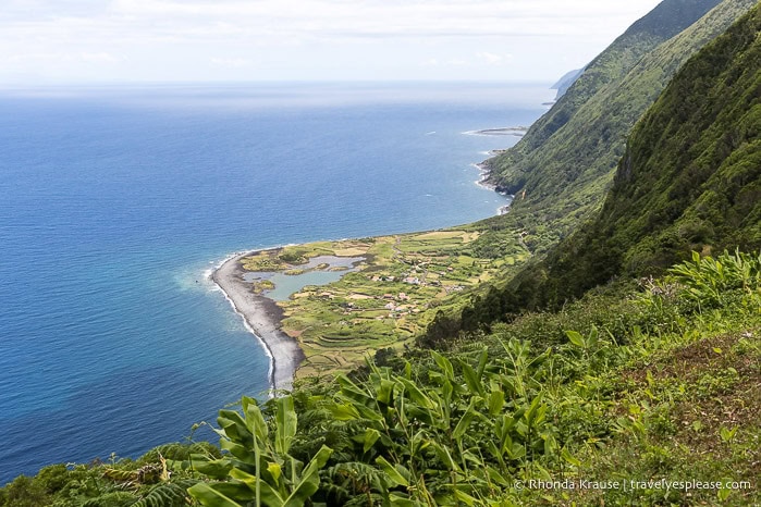
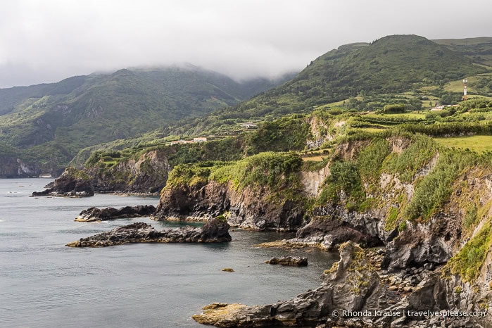
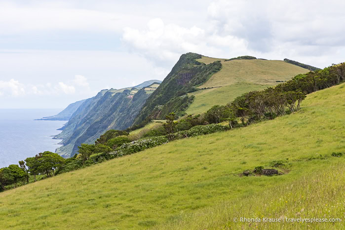
Miradouro da Fajã do Conde was the best of the three viewpoints I stopped at on the southwest coast. From the viewing platform, I could see a flat coastal plain (known as a fajã) at the base of a forested cliff. This was the first of several fajãs I’d see in the Azores, as they’re a distinctive feature of the islands.
Day 2: Day Trip to Corvo Island
The tiny island of Corvo was near the top of my Azores bucket list because of its picturesque crater, the Caldeirão. Sadly, I didn’t get to see the crater because of fog. At least the boat ride to get there was fun!
Sightseeing Boat Trip to Corvo
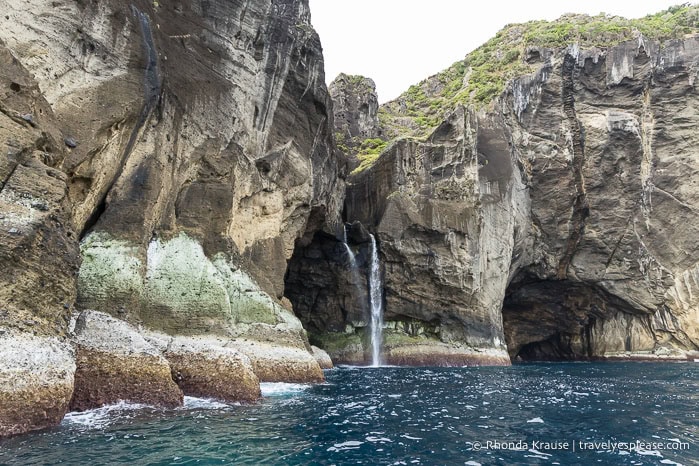
I booked a trip to Corvo on a rigid inflatable boat because, unlike the ferry, it included an exciting sightseeing tour along the northeast coast of Flores.
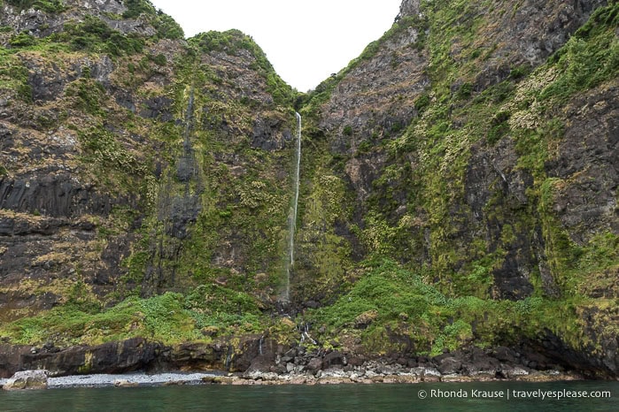
During the trip, we zoomed past towering rock formations, saw waterfalls cascading down cliffs, and went inside sea caves. Crossing over to Corvo, the sea was rough, making for a wet and wild ride!
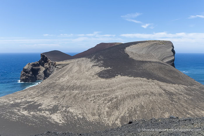
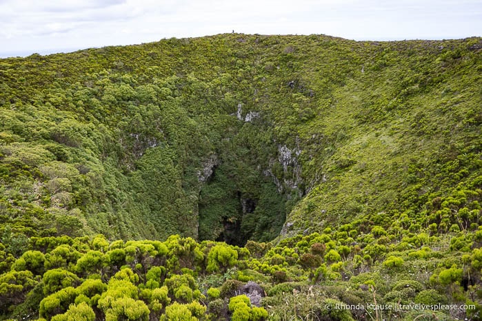
Corvo Island
Corvo’s main attraction is the Caldeirão that dominates the north end of the island. My plan for the day was to get a ride to the crater, hike the loop trail inside it (4.8 km), then walk back to the jetty in the village (about 6 km).
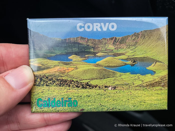
Unfortunately, the fog was so thick that I couldn’t see the crater from the viewpoint at the rim. I walked a portion of the trail to the bottom of the crater and still couldn’t see the lagoon and the scoria and spatter cones. I did, however, find cows, which I was not expecting!
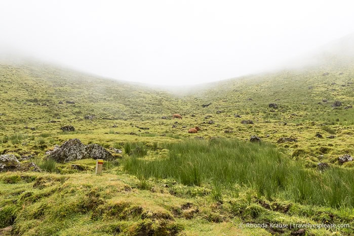
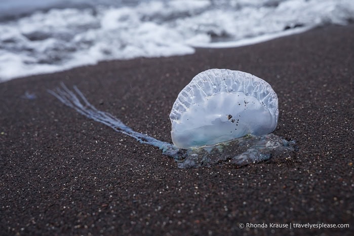
My driver then showed me around the island, including a viewpoint above the village. Afterwards, I walked to Praia da Areia, a black sand beach that had a bunch of Portuguese man o’ war washed up on shore.
Day 3: Explore Central, West, and Northeast Flores
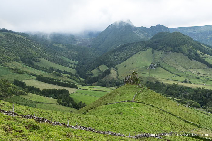
I had plans to visit Flores’ 7 crater lakes- Lagoa Negra, Lagoa Comprida, Lagoa Funda, Lagoa Rasa, Lagoa Branca, Lagoa Seca, and Lagoa da Lomba- since they’re all located on the same plateau in the centre of the island, but saw nothing because of the fog. I also couldn’t see Rocha dos Bordões, a geological formation with columns of volcanic rock. I did get to see two of the island’s most famous waterfalls, an abandoned village, and some viewpoints on the west coast. Since I had time, I drove to the east side of the island to visit some viewpoints north of Santa Cruz das Flores (originally planned for my last day).
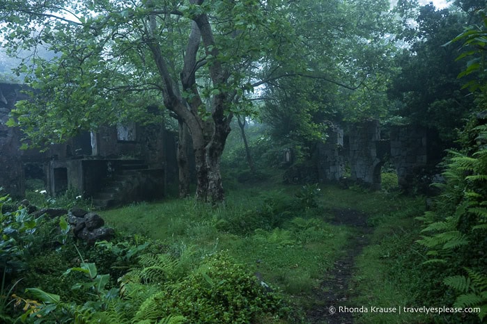
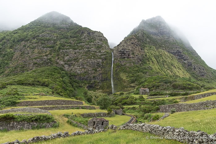
Caldeira do Mosteiro
Caldeira do Mosteiro is an abandoned village in a caldera. The last inhabitant left in 1992 and the buildings, some of which date back to the 19th century, are now in ruin. It was an interesting place for a short walk, especially on a moody, foggy morning.
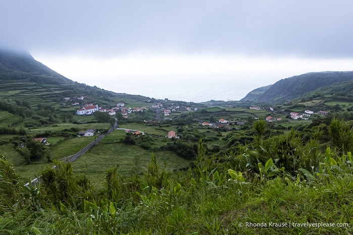
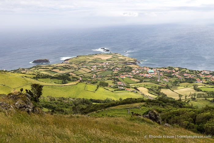
Miradouro da Fajãzinha
The viewpoint above Fajãzinha offers a great view of the tiny village framed by cliffs and the Atlantic Ocean. There’s not much except a few white buildings with orange roofs, a church, and some agricultural fields, but the location is very scenic and worth a photo stop.
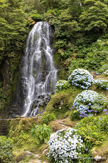
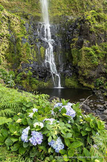
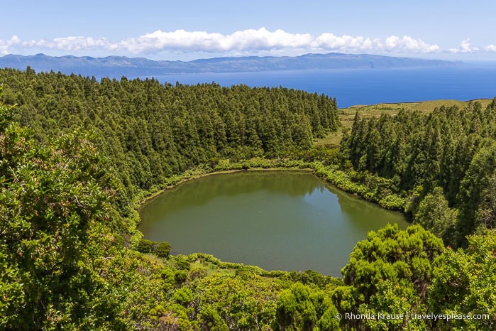
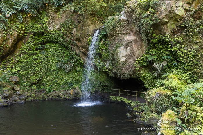
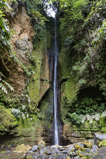
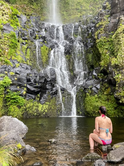
Poço da Ribeira do Ferreiro
Poço da Ribeira do Ferreiro is one of the most beautiful places to visit on Flores Island. This famous waterfall flows in several strands down a lush, green cliff into a large lagoon below.
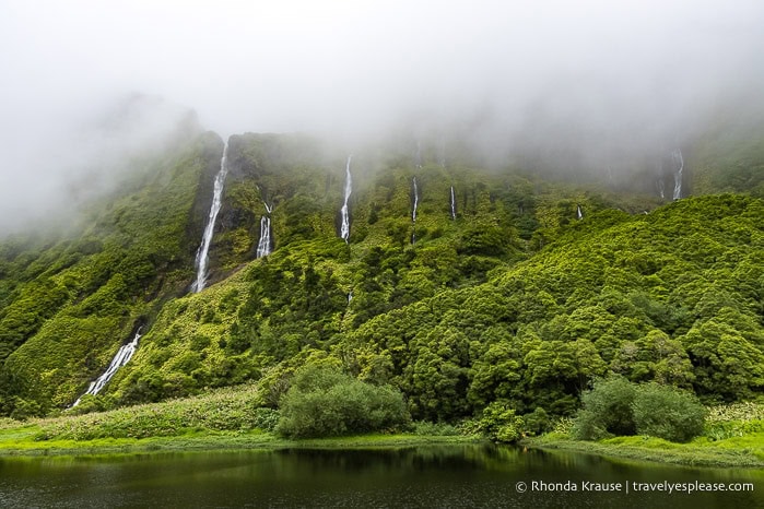
It’s an absolutely stunning location that had me mesmerized (and crying happy tears) even though the top of the waterfall was covered by fog both times I visited.
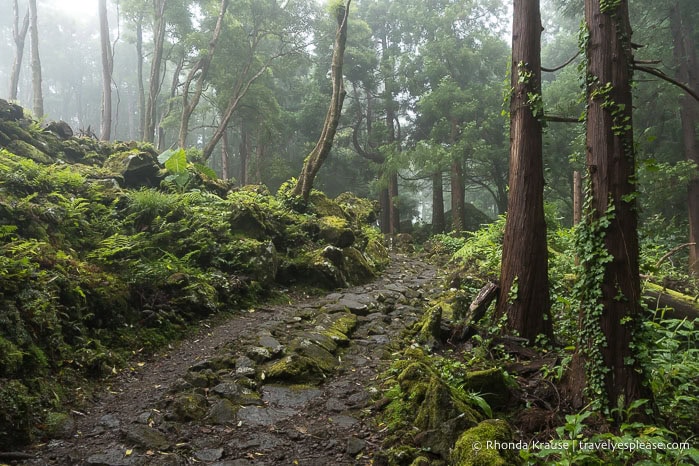
It’s a short 15- 20 minute hike through a forest to reach the falls. The trail is rocky and can be quite slippery, so I don’t recommend hiking it in or after the rain.
Poço do Bacalhau
Another gorgeous waterfall that should not be missed on Flores Island is Poço do Bacalhau in Fajã Grande. The falls tumble about 90 m/300 ft down a rocky mountain into a small pool below.
The plunge pool is great for swimming, since it’s clear and not too cold. One of my favourite memories from Flores Island is swimming below this waterfall, especially since I had it all to myself!
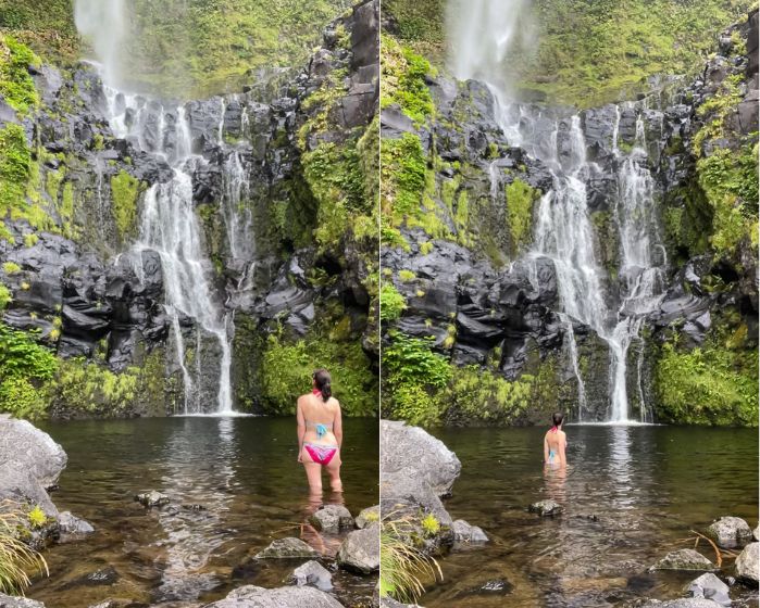
This waterfall is easily accessible via a short trail and is within walking distance of the town.
Aldeia da Cuada
Cuada Village is a 17th century hamlet whose traditional stone farmhouses have been restored into cottages for tourists looking for a cozy, rural retreat.
I didn’t stay here, but strolled around the village to admire the architecture and scenery. It was so pretty and charming that I’d definitely consider staying here if I ever go back to Flores.
Miradouro Pico da Casinha and Miradouro da Moita Alta
Two lower viewpoints that are nice to stop at on the ER2-2 road going west to east across the centre of the island are Miradouro Pico da Casinha and Miradouro da Moita Alta.
Miradouro Pico da Casinha offers a view of Pico da Sé (a trachytic dome), some volcanic necks, and two fluvial valleys.
Nearby is Miradouro da Moita Alta, which has less impressive hills but a nice view of the ocean and Santa Cruz das Flores.
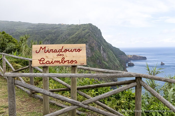
Miradouro dos Caimbros
A short distance north of Santa Cruz das Flores is Miradouro dos Caimbros. This viewpoint looks towards high sea cliffs and some rock formations jutting out of the water.
Miradouro Alagoa and Baía da Alagoa
One of my favourite viewpoints on Flores Island is Miradouro Alagoa at Parque Lazer Alagoa. It’s a short walk to the park, which overlooks Baía da Alagoa and its rock formations. For a closer look at the rocks and cliffs, follow the path down to the beach.
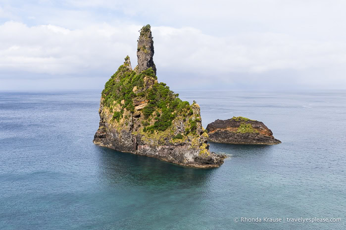
Miradouro do Ilhéu Furado
Another great viewpoint for admiring rock formations and cliffs is Miradouro do Ilhéu Furado. From here I could see a rock arch, a near-vertical cliff face, densely vegetated mountains, and an island.
Day 4: Scenic Drive to the North Coast
My flight got delayed until 4:00 pm, giving me a little extra time to explore Flores. I hoped to see the crater lakes I missed, but they were still covered by fog, so I decided to drive to the northern point of the island. The drive was pretty, and the sights were good enough for a backup plan, but not worth a special trip.
Viewpoints on the North Coast
My first stop in northern Flores was Miradouro de Ponta Delgada. It had a panoramic view of the small town of Ponta Delgada, some fields, and the ocean. On a clear day, I would have also been able to see Corvo.
Next, I visited Miradouro Sobre o Porto e Baía de Ponta Delgada for a view of cliffs and green mountains along the coastline. My last photo stop was Farol de Albarnaz, a lighthouse at the northern tip of the island.
Flores Hits and Misses
Hits:
- The waterfalls, cliffs, and lush mountains. The scenery was gorgeous!
- Many signed, roadside viewpoints to visit.
- The island is not overwhelmed by tourists and I had many places all to myself.
Misses:
- The 1.5 hour wait at the airport for my rental car. Almost everyone from the plane was picking up a car and only one staff member was working for the company I booked with.
- Gas was very expensive. I spent €54 (about $87 Canadian) for a little over half a tank.
- Few hotel choices on the island. Mine was old/retro, basic, and smelled bad.
- Fog and clouds that wouldn’t budge from the top of the island.
Faial Island
2 days, 3 nights
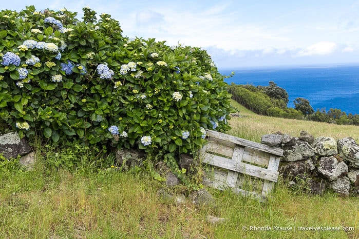
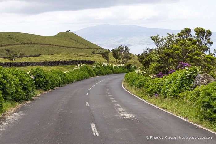
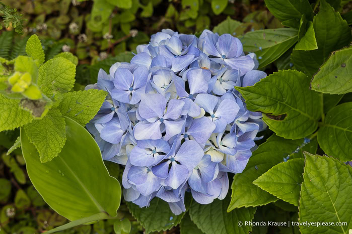
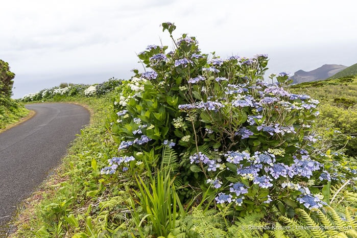
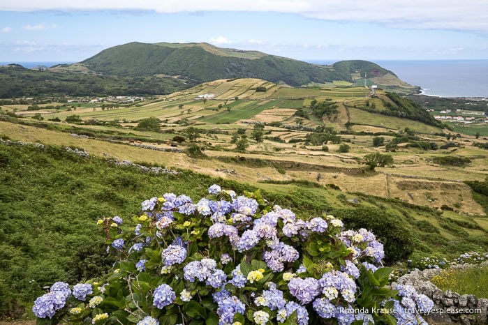
Faial is known as the “Blue Island” because of the large number of blue hydrangeas, but it also boasts some impressive volcanic attractions. During my two days on Faial Island, I did several beautiful hikes, visited viewpoints, and learned about Faial’s (and the Azores’) most recent volcanic eruption.
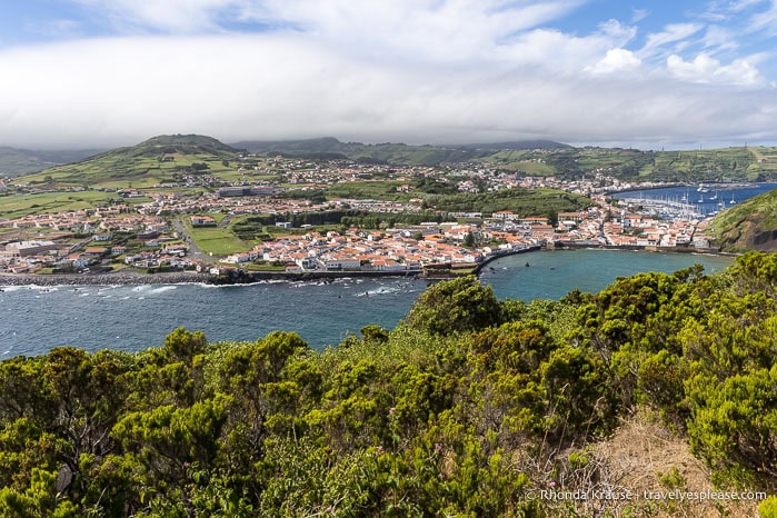
Overnights: Horta
Day 5: Hikes at Caldeira do Faial and Monte de Guia
Today was an active day of hiking at two of Faial’s most beautiful landmarks- the Caldeira in the centre of the island and Monte de Guia in the town of Horta.
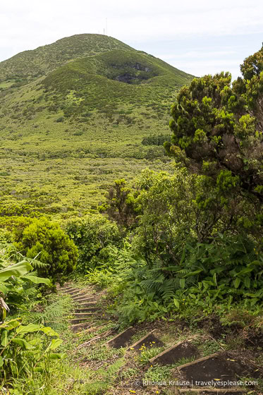
Caldeira do Faial
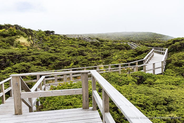
The Faial Caldera is a huge volcanic crater measuring 2 km/1 mi wide and 400 m/1300 ft deep. Its steep slopes and bottom are covered in plants of various shades of green, and the interior even has a scoria cone and a lagoon. The caldera can be admired from a viewpoint and a trail along its rim.
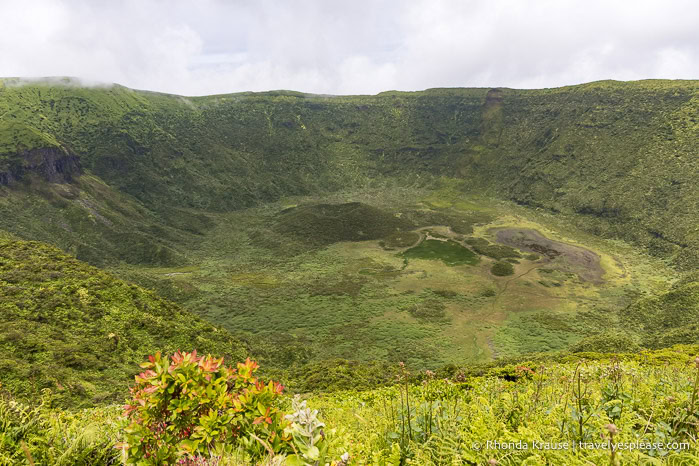
I set out to hike the trail that goes all the way around the caldera, a journey of almost 7 km/4.3 mi. Even though it was insanely windy (I got blown sideways a few times) and the cloud cover was playing hide and seek with the view, I still had a lot of fun on this hike. I enjoyed seeing the caldera from different perspectives, as well as the scenery surrounding the volcano.
Monte de Guia
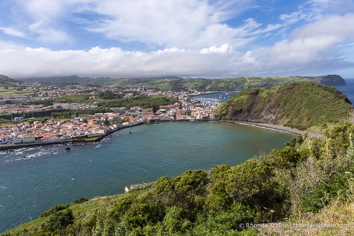
By the Horta port is Monte de Guia, a tuff cone formed by volcanic eruptions near the coast. Over time, it became connected to the mainland by a sandy isthmus.
At the top of Monte de Guia is a lookout point offering great views of Horta to the north and two partially submerged craters to the south. There is a road up to the viewpoint, but I decided to hike the Entre Montes trail instead. The hike is about 2 km/1.2 mi, forming a loop on Monte de Guia that showcases Porto Pim Bay and its beach, the south coast of Faial Island, and the Caldeirinhas/Caldeira do Inferno.
Day 6: Capelinhos Volcano, Hike Cabeço do Canto, Visit Viewpoints
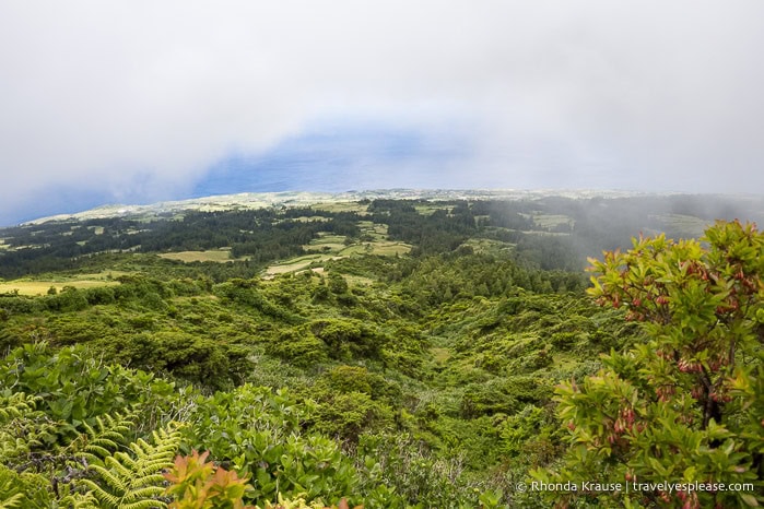
Today I headed to the westernmost point of Faial to see the Capelinhos Volcano and hike a nearby trail. I also stopped at some viewpoints and revisited the caldera since there was no cloud cover.
Capelinhos Volcano and Interpretation Centre
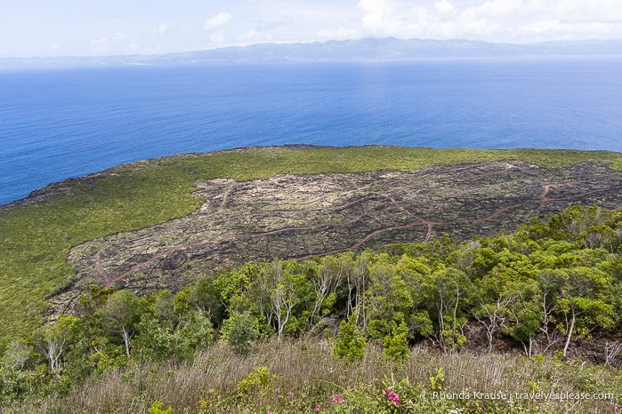
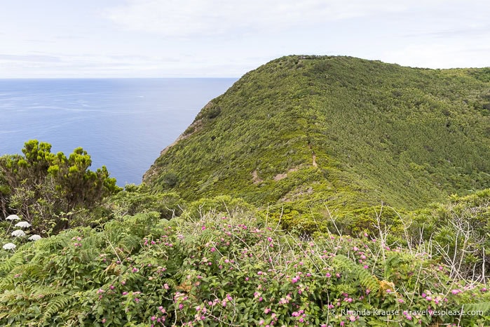
The Capelinhos Volcano, in my opinion, is the most historically and geologically interesting place on Faial. In 1957, this submarine volcano near the coast erupted for 13 months, spewing ash and lava to create a small islet that eventually became connected to Faial, adding 2.4 km² to the island.
This newly formed landscape is unique compared to the rest of the island; its dark, barren rock contrasts with the greenery elsewhere. The shape of the volcano was also striking, with both smooth and rugged features.
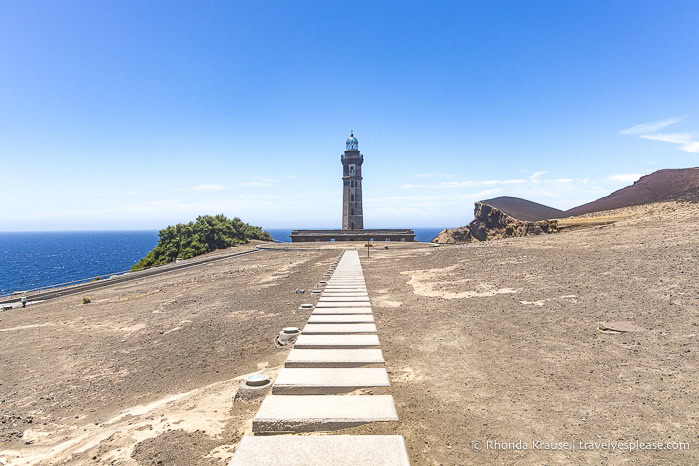
The Capelinhos Volcano Interpretation Centre, built underground so as not to detract from the landscape, was worth visiting to learn more about the eruption and its impact on local communities. Admission includes entrance to the partially-buried Capelinhos Lighthouse that survived the eruption.
Cabeço do Canto Hike
For a relatively short trail (only 2.6 km), the Cabeço do Canto hike sure had an enjoyable variety of scenery. Exploring this protected landscape, I looked down into a volcanic pit, circled two volcanic cones, and passed through a laurel forest. There were even glimpses of the Capelinhos Volcano. My favourite part of the hike was descending the staircase towards a stunning view of the Caldeirão.
Viewpoints
After my hike, I drove up to the top of Cabeco Verde, which I could see from the trail, to take in the views over Faial. On my way back to Horta I stopped at Morro Castelo Branco, a trachytic dome connected to the island by an isthmus. I then went to Miradouro Nossa Senhora da Conceição for views of Horta, its bay, and Monte de Guia.
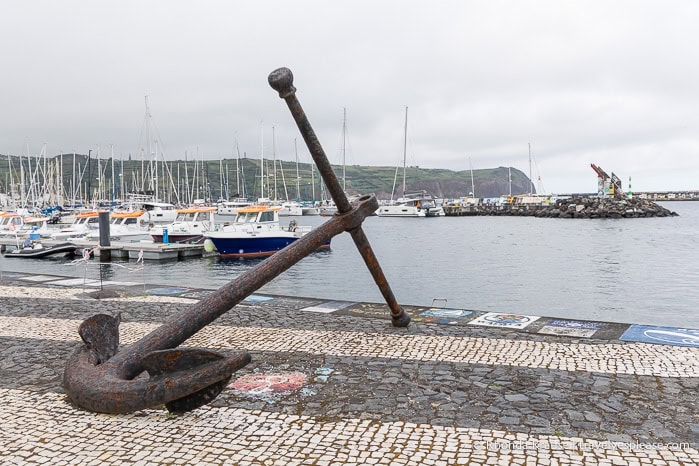
Horta Marina and Jetty Murals
Horta is a lively town with an adventurous spirit that’s on display around its marina.
For centuries, Horta has been a popular stopping point for sailors journeying across the Atlantic and around the world. Before departing Horta, they left behind murals along the marina symbolizing their adventure, a tradition that continues today. It was fascinating to see the murals painted by crews from all over the world and it made me proud to be on my own little adventure, travelling solo for 3 weeks in the Azores.
Faial Hits and Misses
Hits:
- Hiking around the caldera.
- The views from Monte de Guia.
- The volcanic scenery, especially Capelinhos and the cones on the Cabeço do Canto hike.
- The atmosphere and architecture of Horta.
Misses:
- High winds and poor visibility during my hike around the caldera (and the forecast wrongly telling me that it was going to be the way better day to hike).
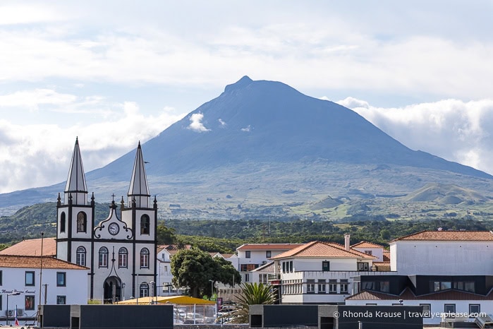
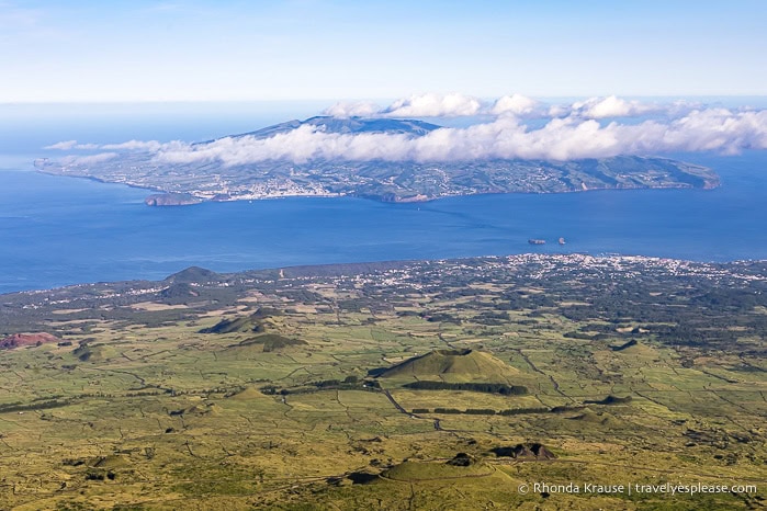
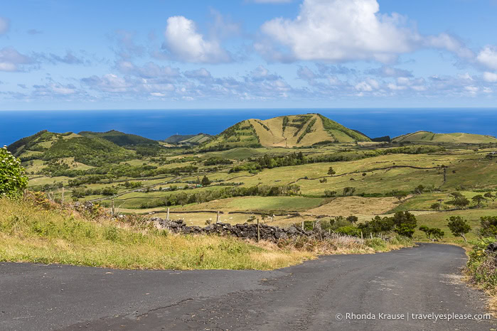
Pico Island
2.5 days, 3 nights
Pico Island was one of the main highlights of my Azores trip, which I didn’t think it would be since its nickname, the Gray Island (referencing the amount of exposed lava rock), didn’t inspire me. Turns out, Pico had many beautiful sights beyond its distinctive volcano and basalt-walled vineyards.
Overnights: Madalena
Day 7 (PM): See the Frade Windmill, Drive the EN3 Road, Visit Viewpoints and Interpretation Centres
After arriving by ferry, I had a full afternoon to explore. I visited a windmill, a lake, some viewpoints, and two small interpretation centres. I wanted to see Torres Cave, the largest lava tube in Europe, but it was temporarily closed for safety reasons. The visitor centre was still open, so I got to watch the video that is shown at the start of tours.
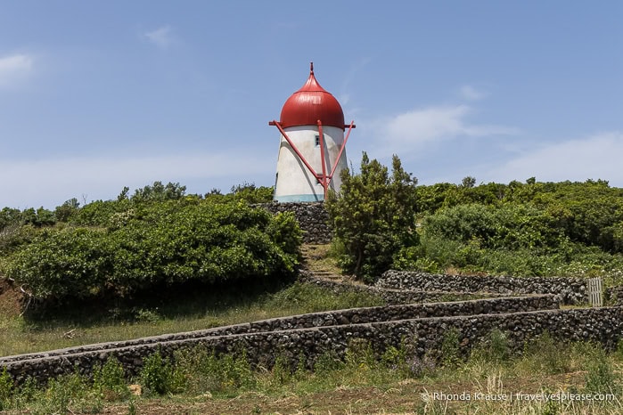
Frade Windmill
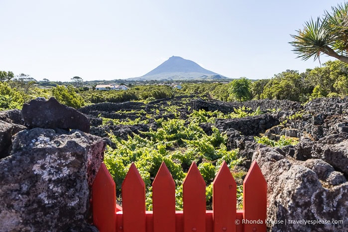
Just south of Madalena is Pico’s most famous traditional windmill. With its cute red cap, the Frade Windmill stands out among the dark, volcanic stone walls of the vineyards surrounding it.
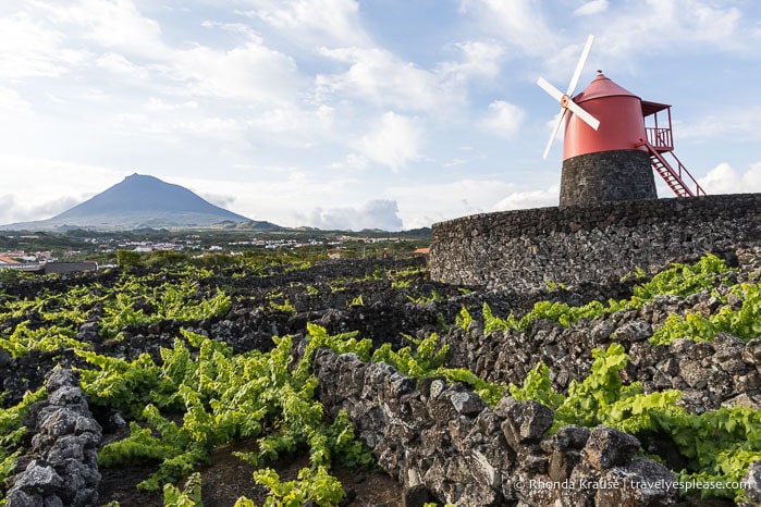
From the top of the windmill, I could overlook the grid of currais (pens made of basalt that the vines grow in). On a clear day, there are great views of Mt. Pico to the east and Faial Island to the west.
The EN3 Road and Lagoa do Capitão
My guidebook called the EN3 one of the most beautiful roads in Portugal. It was pretty, with views of Mt. Pico, green hills, and the ocean, but it wasn’t the most scenic drive I did on the island.
The main attraction on the EN3 is Lagoa do Capitão (Captain’s Lake), a small lake known for its reflections of Mt. Pico, which I didn’t get to enjoy because of clouds.
Viewpoints on the North Coast
On the north coast, I visited Miradouro São Miguel Arcanjo for a view of the village of São Roque do Pico and its surrounding volcanic landforms. I then went to Miradouro Prainha to see Ponta do Mistério and its fajã with São Jorge Island in the background.
Casa dos Vulcões and Landscape of the Pico Island Vineyard Culture Interpretation Centre
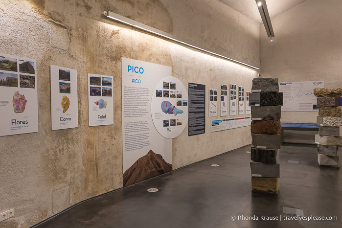
Volcanoes’ House is a small interpretive centre that presents information about volcanoes, volcanic activity, and the volcanic landscape of Pico and other Azores islands. There’s also a video showing what it would look like to travel to the Earth’s core and a seismic simulator.
Next door is the Landscape of the Pico Island Vineyard Culture Interpretation Centre, which has a few exhibits about the history of Pico’s winemaking. It wasn’t really my thing, but worth checking out since I was in the area and admission was free.
Day 8: Hike Mt. Pico
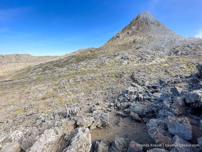
Today I climbed Mt. Pico, an incredible 7 km/4.3 mi round trip hike that took me almost 7 hours (average is 8-9 hours).
Mt. Pico Hike
Climbing Mt. Pico was the reason I came to Pico Island and one of the things I was most looking forward to on my Azores trip. The experience was so much fun, but a bit challenging in places because of steepness and rocky terrain.
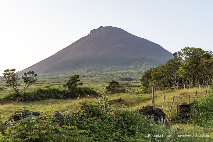
As is recommended, I did this hike with a guide because the route can be tricky (there are posts to follow, but not always an obvious trail). I loved the views as I climbed the volcano and reaching the crater was so satisfying. The best part was scrambling up to Piquinho, the little peak that overlooks the crater, to reach the highest point in Portugal at 2351m/7713 ft.
Day 9: Hike the Vineyard Trail, Visit Furna do Frei Matias, Drive the Lagoon Road
For my last day on Pico, I did a 2 hour hike through the vineyards, visited a cave, and took a scenic drive along the Lagoon Road.
Hike Vinhas da Criação Velha
An easy and enjoyable way to explore Pico’s vineyard landscape is by walking the “vineyard trail” from Porto do Calhau to Madalena.
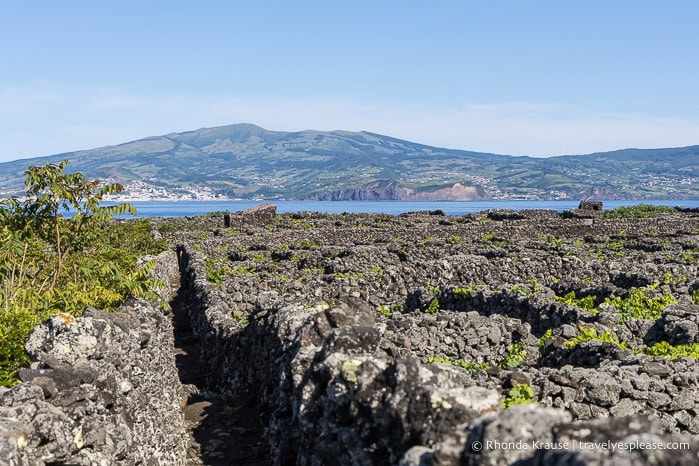
The route alternates between following the coast, offering views of Faial Island, and moving inland to wander between stone walls sheltering grape vines. It also passes by the Frade Windmill and has wonderful views of Mt. Pico.
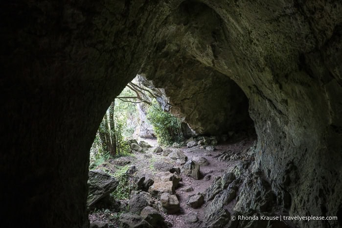
Furna do Frei Matias
Unlike Torres Cave, Furna do Frei Matias is relatively unknown and is not a tourist cave (so enter at your own risk). I only discovered it while looking at Google Maps for more places to see along the EN3.
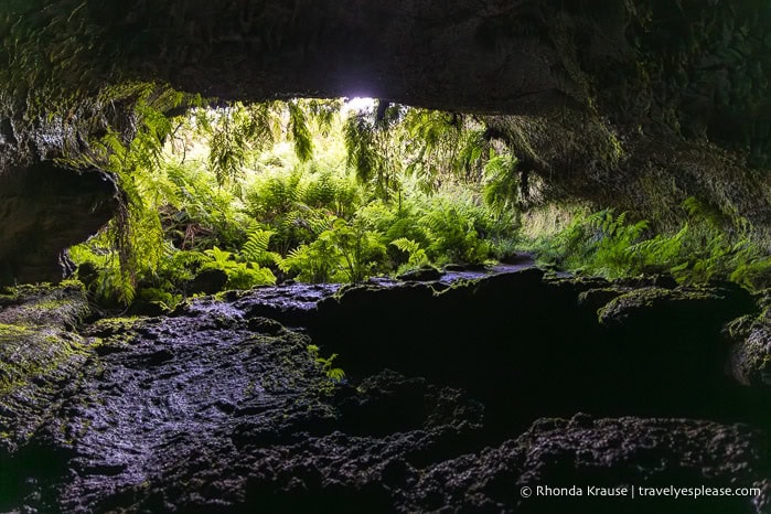
The entrance to the cave is beautifully framed by ferns and the ceiling is high enough to stand in most places. It was very dark inside, so I had to walk carefully on the rough, hardened lava.
Drive Lagoon Road
My favourite drive on Pico Island was along Estrada das Lagoas (Lagoon Road). This remote, lesser-travelled road runs across the middle of the island’s eastern half, showcasing the beauty of the Achada Plateau volcanic mountain range.
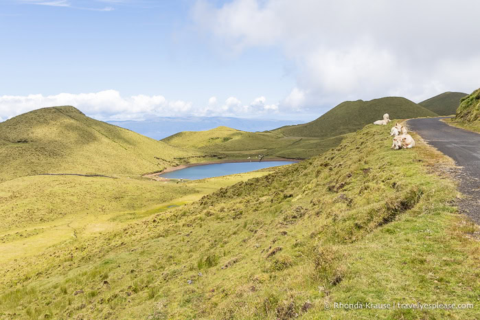
The road passes by several lagoons, including the island’s largest lake, Lagoa do Caiado. While the lagoons were pretty, the highlight of the drive for me was seeing the alignment of volcanic cones on the plateau.
Pico Hits and Misses
Hits:
- Perfect conditions for hiking to the summit of Mt. Pico. I loved looking down on the crater from Piquinho!
- The unique vineyard landscape.
- Taking pictures of all the volcanic cones and lakes along Lagoon Road.
- The earthquake simulator at Volcanoes’ House was an interesting experience.
- Madalena had everything I needed within walking distance of my hotel.
Misses:
- Torres Cave being closed.
São Jorge Island
1.5 days, 2 nights
Long and narrow, São Jorge Island is known for its tall cliffs rising from the sea and its coastal fajãs. I came here specifically to do the island’s top hike, but found several more ways to enjoy São Jorge’s natural beauty.
Overnights: Velas
Day 10 (PM): Explore the Northwest End of the Island, Stroll Around Velas
My ferry from Pico arrived at 11:15 am, so I had the afternoon to go sightseeing. I drove to a viewpoint on the northwest end of the island, visited a forest park, then walked around Velas.
Ponta dos Rosais
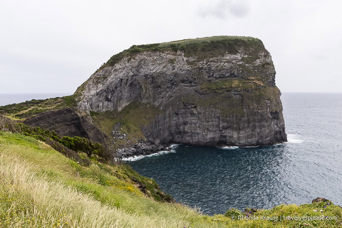
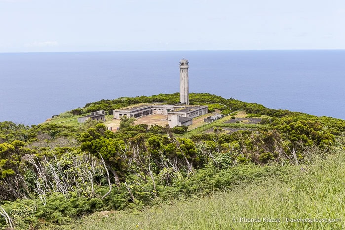
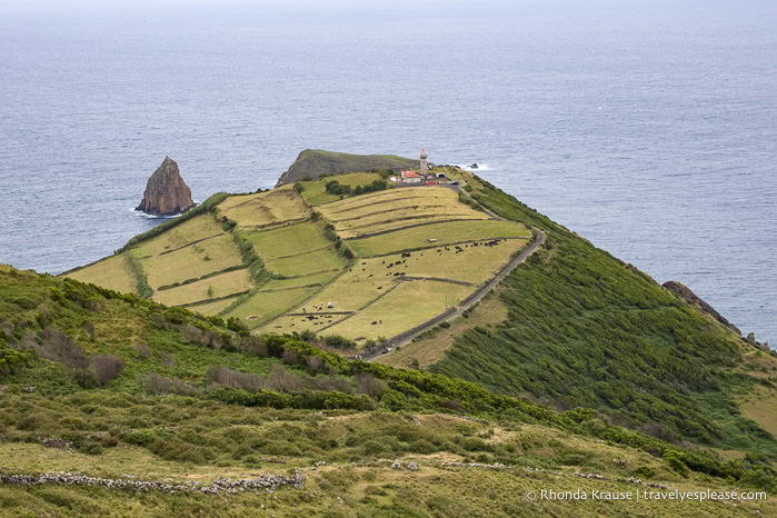
Rosais Point, a protected area at the northwest tip of São Jorge, features an observation deck and an old abandoned lighthouse.
The lighthouse complex is in a state of disrepair, damaged by an earthquake, a storm, and then neglect, so it has an eerie look to it.
Just before the lighthouse is a path leading up to Vigia da Baleia, an old whaling lookout. There are panoramic views of the ocean and neighbouring islands of Pico, Faial, and even Graciosa on a clear day (I saw all three). What I liked best was seeing the smooth, grassy top of a nearby cliff.
Parque das Sete Fontes
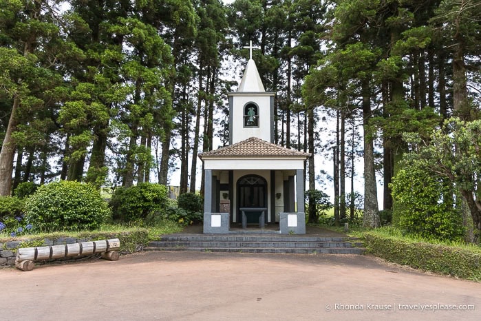
The Sete Fontes Forest Park is a pleasant place to stop for a shady picnic and stroll. I was impressed by the diversity of trees and plants as I walked the paths that weave through the forest around ponds and streams. I even saw some baby ducks. The most photogenic spot is the little white chapel of São João Baptista.
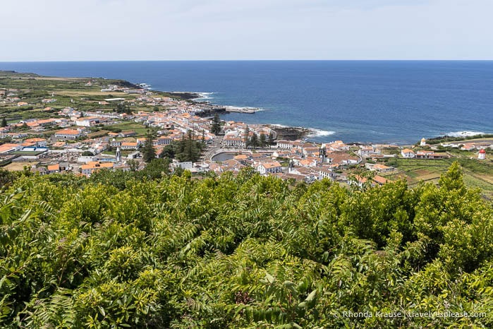
The park has road access to two viewpoints that should not be missed. At Miradouro Ferrã Afonso, I saw tall coastal cliffs and at Miradouro do Pico da Velha, I admired stunning views of Pico Island and São Jorge’s landscape stretching southeast toward Velas.
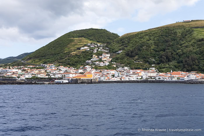
Velas
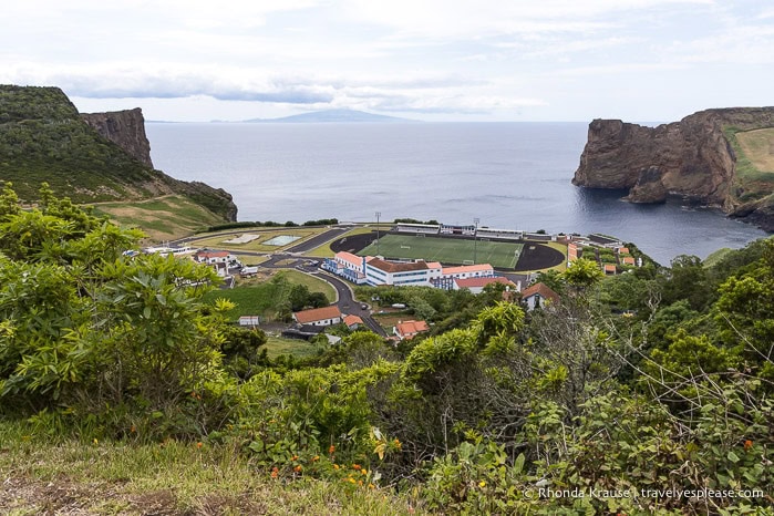
The little seaside town of Velas is enjoyable to wander through. The main square and area around it are especially pretty with decorative cobblestone paving and historic buildings, including some fine examples of 18th century Azorean Baroque architecture. The colourful República Garden is a great place to sit and rest, as is the observation deck by the natural arch if you’re walking west along the shore.
Just outside of Velas, there’s a roadside viewpoint worth stopping at called Miradouro do Canavial. Here I saw the most scenically located soccer field- alongside a bay between two submarine volcanoes!
Day 11: Hike Serra do Topo to Fajã dos Cubres, Swim at Simão Dias Natural Pool
Today I did a wonderful hike through the mountains down to the coast. Afterwards, I went swimming at one of the island’s most scenic swimming spots.
Hike Serra do Topo- Caldeira de Santo Cristo- Fajã dos Cubres
One of the most beautiful hikes I did during my 3 weeks in the Azores was the trail that starts at the Serra do Topo mountain range, passes through Fajã Caldeira de Santo Cristo, and then ends at Fajã dos Cubres.
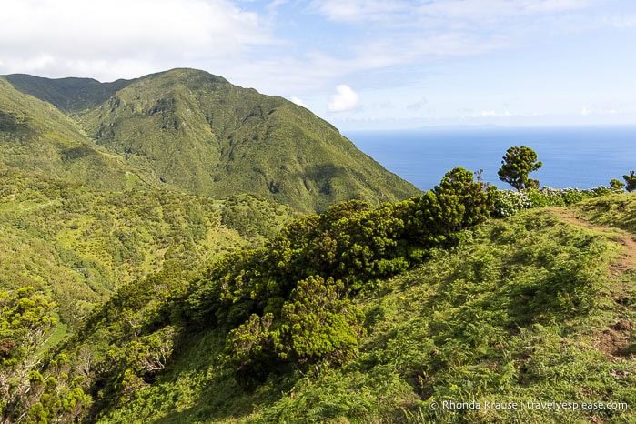
I loved walking along the ridge, surrounded by lush green mountains, then descending through a valley toward the ocean. Once at the coast, I passed through two fajãs with small communities nestled between the sea and the cliffs. This hike alone was worth coming to São Jorge for, thanks to its gorgeous and varied scenery.
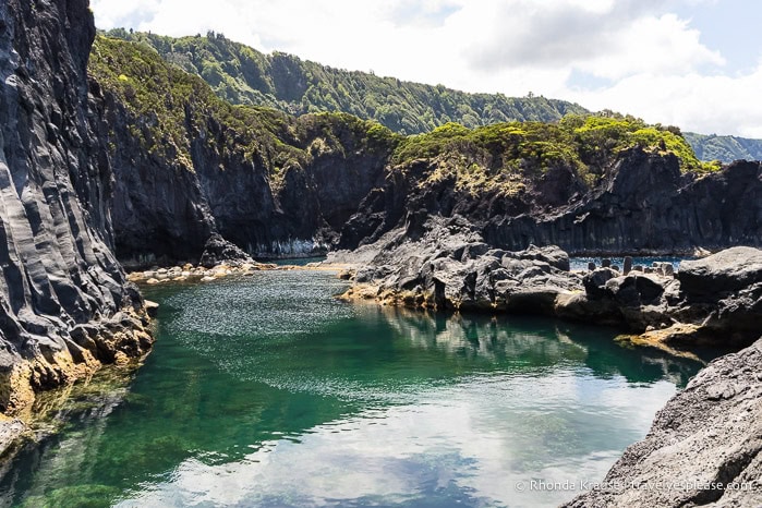
Swim at Poça Simão Dias
I had to make sure I included at least one natural swimming pool on my Azores itinerary, since they’re so popular on the islands, and decided on Poça Simão Dias in Fajã do Ouvidor.
With black volcanic cliffs and clear turquoise water, this pool was definitely the most stunning one I saw. I’m normally not a fan of swimming in the ocean, but it was such a pleasure to swim where the natural landscape acts as a shelter against the waves.
São Jorge Hits and Misses
Hits:
- Hiking in the mountains.
- The steep green cliffs and scenic fajãs.
- Relaxing at a natural pool.
- Staff at the tourist information office in Velas were helpful.
Misses:
- A street festival in Velas had a stage steps away from the wall of my hotel with bands playing stadium volume music until 4:00 am, on a Thursday! It was so obnoxious. When I asked the front desk staff if this would be going on all night, he looked at me like I was an idiot and rudely said, “Yes, it’s a festival.” I got almost no sleep for 2 nights!
Graciosa Island
2 days, 2 nights
Graciosa is overlooked by most tourists who visit the Azores, which is precisely what I liked about it. Being the second smallest island with not a lot to see and do made it a great place to slow down and relax. Its main attraction is a huge lava cave, which was impressive enough to make the trip here worthwhile.
Overnights: Santa Cruz da Graciosa
Day 12: Explore Around the Caldera, Visit Furna do Enxofre
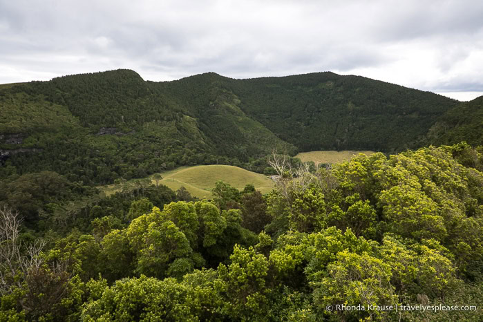
I spent the day exploring around and inside the Graciosa Caldera. I drove the perimeter of the caldera, stopping at viewpoints along the way, then descended into the caldera to visit the “Sulphur Grotto”.
Drive Around the Caldera
I originally thought this route was a hiking trail (it’s called Volta à Caldeira- Furna do Enxofre, Trail PRC02 GRA), but when I went to scout it out, I discovered it’s actually a road. I decided to drive instead of hike, which was the better choice.
The road circled the caldera but wasn’t high enough to see inside the crater. Instead, there were several roadside viewpoints overlooking the island.
The highlight of the drive was visiting Furna da Maria Encantada, a small lava tube on the slope of the caldera. After walking through the tunnel, there’s a view into the caldera, partially obstructed by trees.
Furna do Enxofre
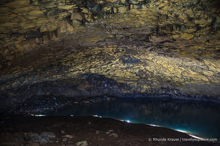
Furna do Enxofre was the most remarkable cave I visited during my 3 week trip to the Azores.
Named the “Sulphur Grotto”, this volcanic cave has a degassing field releasing carbon dioxide, hydrogen sulphide, and other gases, so access is only allowed when the levels are safe.
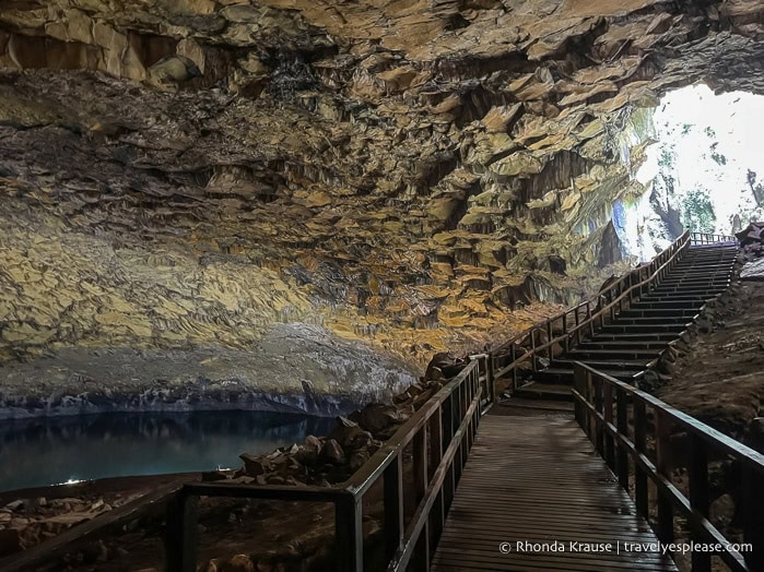
The cave is huge with a diameter of about 200 m/656 ft and a 50 m/164 ft high ceiling. Most impressive was the vaulted roof and its lava prisms, but I also enjoyed watching the bubbling mud fumarole and seeing the cave’s lake.
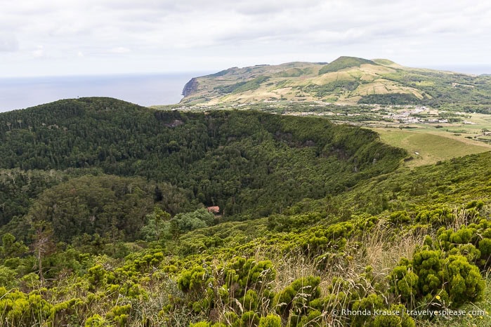
Day 13: Caldera Rim Hike, Sightseeing Drive Around the Island
In the morning, I hiked a trail that went around the rim of the caldera. My afternoon was spent sightseeing on the west side of the island and visiting some places of interest near Santa Cruz da Graciosa.
Caldera Rim Hike
The previous day, I discovered a trail that went up to the ridge of the caldera, so I decided to explore it further. Turns out, it was what I expected Trail PRC02 GRA to be, going around the rim with views into the caldera at some points.
The trail starts at Furna da Maria Encantada, goes uphill to a wooden tower that offers the area’s best view of the caldera, then proceeds almost all the way around the rim.
The route around the caldera is not an official hike. Most of it is part of Trail PRC05 GRA, and is signed as such, which caused me some confusion. The trail also doesn’t technically circumnavigate the caldera. To complete the circle requires hopping over a low wall and cutting through a private field for a short distance, so if you don’t want to trespass, I recommend that when you reach this point, you follow the signed trail down into the caldera and up the opposite side to get back to the start.
Sightseeing Drive
From the caldera, I drove along the west side of the island back to Santa Cruz da Graciosa, stopping at places on the map that sounded interesting.
I visited Ponta do Carapacho (a viewpoint and lighthouse), Caldeirinha de Pêro Botelho (a volcanic pit), Porto Afonso (a fishing harbour surrounded by reddish volcanic rocks), and Miradouro Ponta da Barca (a viewpoint and lighthouse). My favourite stop, and a must-see, was the caldeirinha.
Sights Near Santa Cruz da Graciosa
Two places I wanted to briefly visit on the outskirts of Santa Cruz da Graciosa were Moinho de Vento das Fontes and Monte da Senhora da Ajuda.
Moinho de Vento is a windmill that’s part of the Graciosa Museum. Unfortunately, it wasn’t open to see inside, but I liked the onion-shaped roof.
Monte da Ajuda has excellent vistas over Santa Cruz da Graciosa and three historic chapels, including the Gothic 16th century Hermitage of Nossa Senhora da Ajuda. There’s also a bullring inside the crater.
Graciosa Hits and Misses
Hits:
- Having Furna do Enxofre all to myself. The only sounds were the bubbling mud pot and water dripping from the cave’s ceiling.
- The views around the caldera.
- Caldeirinha de Pêro Botelho was an interesting discovery and even had a viewpoint that labelled the scoria cones on the landscape.
Misses:
- No official hiking trail that goes all the way around the rim of the caldera. The only official “hike” that completely circles the caldera is actually a road, not a trail, and doesn’t have any views of the caldera’s interior.
Terceira Island
2 days, 2 nights
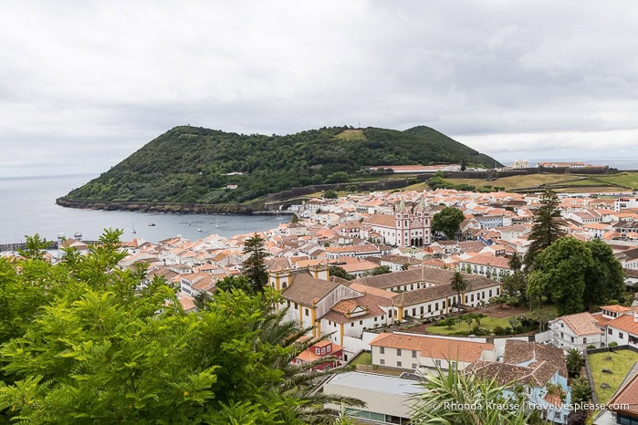
Terceira is one of the more popular Azores islands, in part because it’s the only one besides São Miguel that has an international airport. Terceira also has the second-largest population. The island has several volcanic attractions and is home to the Azores’ oldest town, Angra do Heroismo, a UNESCO World Heritage Site.
Overnights: Angra do Heroismo
Day 14: Visit Viewpoints, Furnas do Enxofre, and Natal Cave
Today I planned to visit the island’s best-known volcanic attractions- Algar do Carvão, Furnas do Enxofre, and Gruta do Natal, which are all near each other in the centre of the island. Unfortunately, Algar do Carvão, Terceira’s most famous cave, was closed due to the construction of a new visitor centre. I also visited some viewpoints, but decided I was too tired to hike the Misterios Negros Trail as I had planned.
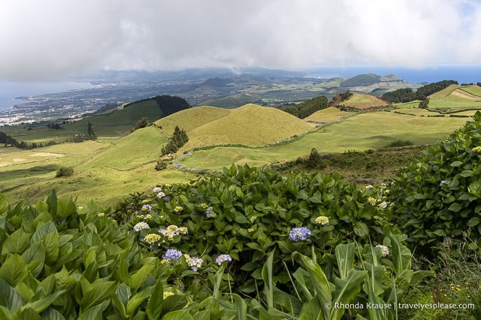
Miradouro da Serra do Cume
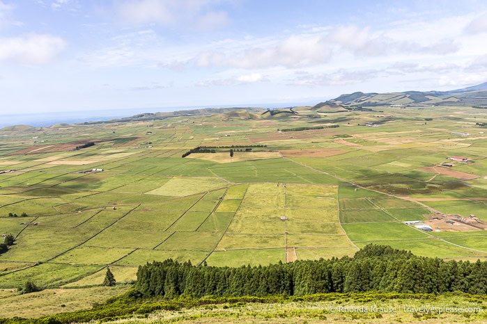
My first stop from the airport was the Serra do Cume viewpoint. There’s a wooden platform extending out from a hillside to overlook a pretty patchwork of green fields. In the background is a row of volcanoes and some scoria cones. It was a lovely spot to get an introduction to Terceira’s landscape.
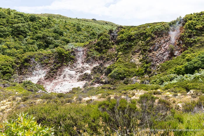
Furnas do Enxofre
An interesting and scenic place to wander around is the Furnas do Enxofre fumarole field. Along the boardwalk circuit, I passed by several steaming fumaroles that smelled of sulphur. It doesn’t compare to what I saw in Yellowstone National Park in the USA, and the area was smaller than I expected, but I still enjoyed seeing steam rise out from cracks in the earth.
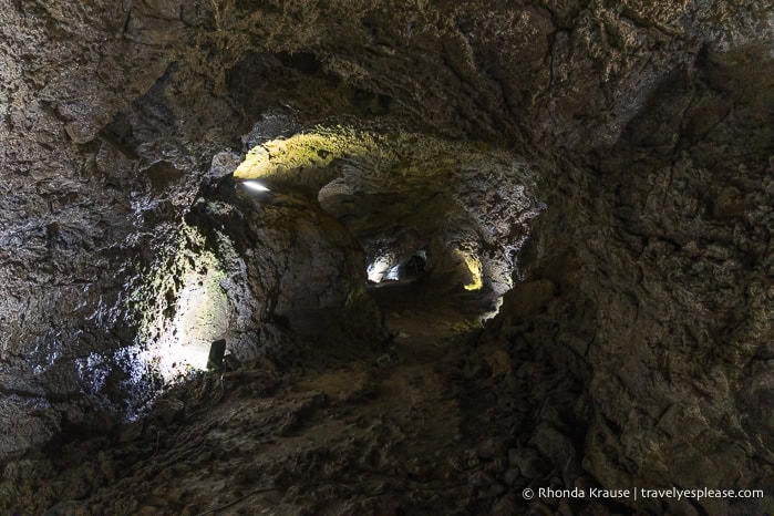
Gruta do Natal
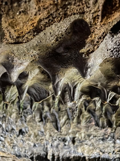
The Natal Cave is a must-see lava tube. I was very impressed by the visitor experience, geology, and size of the cave, even though its full length (697 m/2286 ft) can’t be visited.
I was fascinated by the textures and forms of the hardened lava and appreciated that signs pointed out and explained the tube’s features, including flow lines, stalagmites, and stretchmarks.
Serra de Santa Bárbara
Within a protected nature reserve is Serra de Santa Bárbara, a dormant volcano and Terceira’s highest peak. At the top is a boardwalk with viewpoints looking south over the island. A second boardwalk to the north descends into an area rich with endemic flora, including Azores juniper and laurel. There’s also a peatbog plateau.
Day 15: Hike on Monte Brasil, Explore Angra do Heroismo
Today I stayed in Angra do Heroismo, exploring the city’s charming historic centre and hiking on Mount Brasil.
Monte Brasil
Jutting out between Angra Bay and Fanal Bay is Mount Brasil, a forested extinct volcano. You can drive up to the top, but I opted to hike instead, checking out the Monte Brasil Route.
During my 8 km hike, I enjoyed views of Angra do Heroismo and its bay, spotted some deer, visited a cat colony, rested at a ruined fort, gazed at the sea from an old whale lookout, saw a caldera, and photographed some monuments. All the attractions, beautiful views, and quiet forested areas made Mount Brasil a joy to hike.
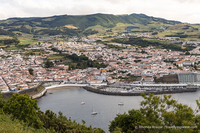
Angra do Heroismo
From the parking lot at Mount Brasil, I walked into town to see a few places of interest in Angra’s historic district. My favourites were Iglesia de la Misericordia (a blue church overlooking the marina), the central square (Praça Velha) and its Town Hall, and the Duke of Terceira Garden and view from its “Memory Hill”.
Terceira Hits and Misses
Hits:
- Being the first person inside Natal Cave when it opened for the day.
- The scenic, zigzagging drive up to Serra de Santa Bárbara.
- The scenery, wildlife, and variety of attractions on Mount Brasil. It was so nice to go hiking in a natural area without having to leave town.
- The architecture in Angra do Heroismo.
Misses:
- Not getting to visit Algar do Carvão because of construction.
São Miguel Island
6.5 days, 6 nights
São Miguel is the Azores’ largest and most popular island to visit. While there was a noticeable increase in crowds compared to the other islands, I found some lovely places off the typical tourist trail. São Miguel has so many must-see attractions, from crater lakes and waterfalls to hot springs and gardens, that I easily filled an extra day when my flight got cancelled.
Overnights: Ponta Delgada
Day 16: Walk Around Ponta Delgada
Today I walked around Ponta Delgada, a city that didn’t really interest me, but I couldn’t get my rental car until the afternoon, so had no other choice.
Ponta Delgada
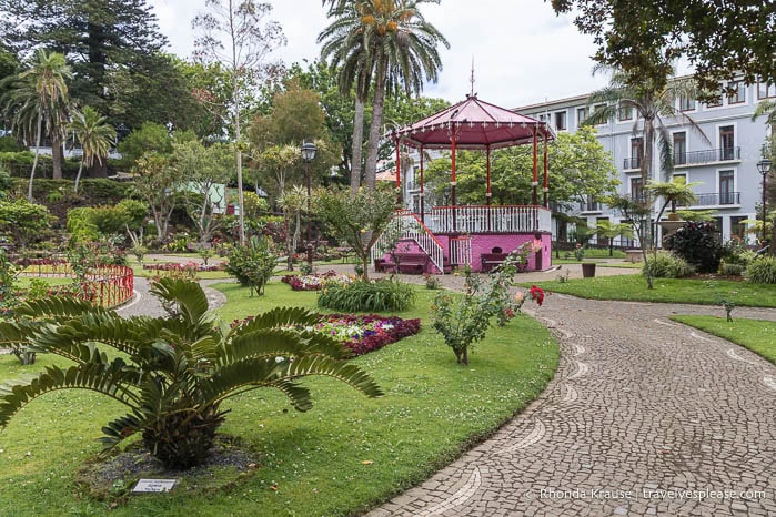
My self-guided walking tour of Ponta Delgada was mostly in the city centre, venturing a little bit north to visit Jardim António Borges, a botanical garden that had some interesting exotic trees.
In the city centre, I saw the Fort of São Brás, the Emigrant Monument, Campo de São Francisco (a square with decorative paving and a big tree from Australia planted in 1870), the 18th century city gates, Igreja Matriz de São Sebastião (church with intricate carvings decorating the interior), and City Hall (I went up the bell tower for a view of the city).
Day 17: Explore the Sete Cidades Area
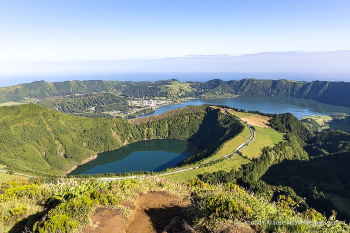
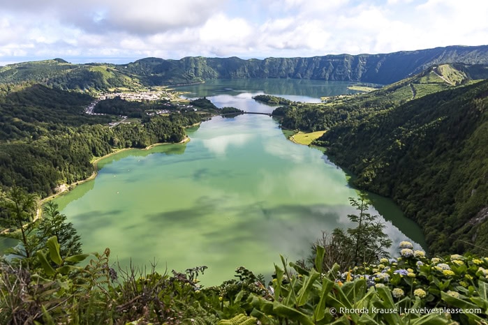
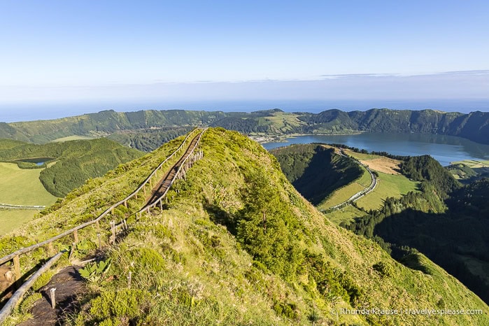
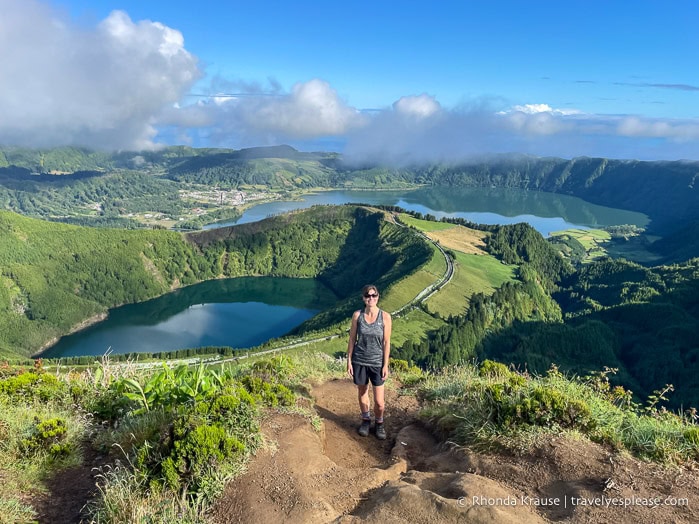
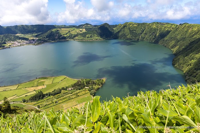
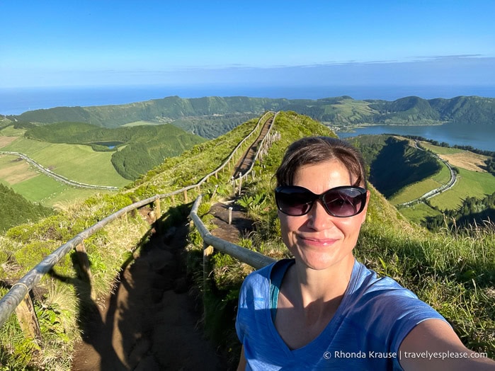
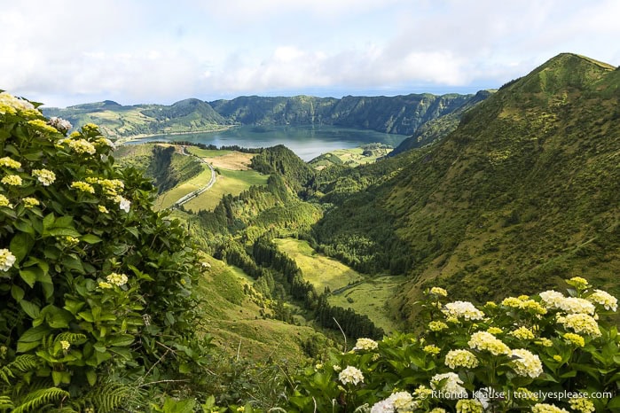
The Sete Cidades caldera and its twin lakes are São Miguel’s most iconic attraction and its surroundings are worth dedicating at least an entire day to exploring. I had a wonderful time visiting viewpoints and hiking around the caldera on my first of two visits to the area.
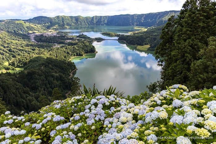
Miradouro da Grota do Inferno
One of the places on my Azores trip itinerary that I was most looking forward to seeing was the Grota do Inferno viewpoint. The simplest way to describe it is “wow!”
A narrow path on a picturesque ridge leads to a lookout with views of Lagoa de Santiago in a crater and the larger Lagoa Azul (Blue Lake) in the background. I could also see Lagoa Rasa, the smallest crater lake in the Sete Cidades caldera.
The scenery was so stunning that I came here twice. The second time, I was lucky enough to have the viewpoint all to myself- such an incredible moment!
Miradouro da Vista do Rei
The Vista do Rei viewpoint is a very popular spot on the south end of the caldera to admire the twin lakes- the blue Lagoa Azul and the green Lagoa Verde.
The view is very beautiful, especially with hydrangeas in the foreground, but I didn’t enjoy the atmosphere. It gets so crowded, especially when tour buses roll up.
Miradouro do Cerrado das Freiras
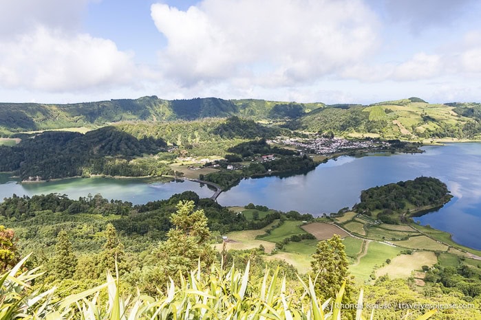
For a view from the east side of the caldera, I headed to Miradouro do Cerrado das Freiras. This spot gives a side-by-side look at the twin lakes and the bridge splitting them. I could also see Sete Cidades village in the distance.
Hike Mata do Canário- Sete Cidades
Another incredible hike on my Azores itinerary was the trail from Mata do Canário to Sete Cidades village.
The 12 km/7.4 mi route follows the crest of the caldera, offering gorgeous views of all four of the Sete Cidades lakes, plus the surrounding hills, meadows, and sea. Once you reach the village, there’s a taxi stand by the São Nicolau church where you can get a ride back to the trailhead.
Miradouro do Pico do Carvão
Leaving the Sete Cidades area, I stopped at the Pico do Carvão viewpoint, which looks out at the northwesternmost part of the Picos Volcanic Complex. I saw several volcanic cones and the north and south coasts of the island.
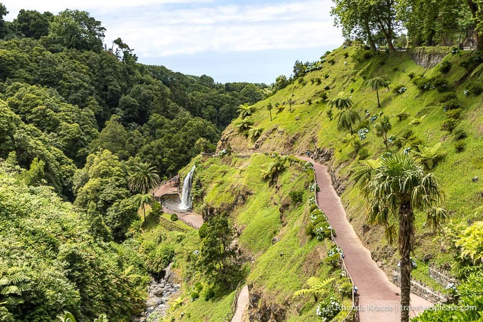
Day 18: Explore the Lagoa do Fogo Area, Visit Gorreana Tea Plantation and Cascata do Limbo
I arrived at Fogo Lake around 7:30 am, giving me plenty of time to visit the three viewpoints before the road closed at 9:00 am, when a shuttle bus becomes mandatory (until 7:00 pm). Unfortunately, the lake was hidden by thick cloud cover. I then went for a soak at the nearby hot springs when they opened at 9:00 am. The rest of my day was spent visiting waterfalls and a tea plantation.
Caldeira Velha Thermal Pools
The Caldeira Velha thermal pools are the most beautiful hot springs I’ve visited, located in a lush tropical forest.
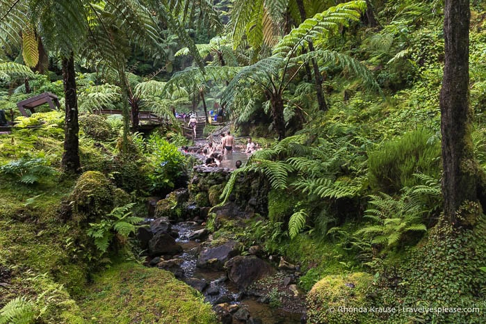
There are four thermal pools you can soak in, each at a different temperature. My favourite was the one with the waterfall. Even though the pools are small and crowded, I still loved the atmosphere and wild, natural setting.
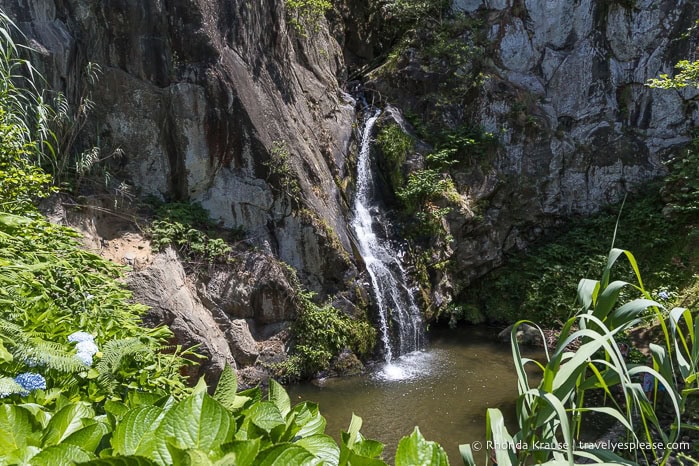
Salto do Cabrito Waterfall
Not far from Caldeira Velha is Salto do Cabrito, a slender waterfall flowing between a gap in a cliff face. The waterfall’s plunge pool is a popular swimming spot.
This was probably my least favourite of the São Miguel waterfalls I saw, and I didn’t think the area was very scenic, but it was worth a quick stop since I was in the area.
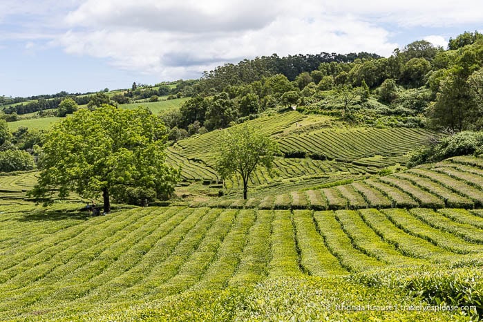
Gorreana Tea Plantation
Gorreana is the oldest tea plantation in Europe and has become quite the tourist destination since starting production in 1883. I hiked one of the trails that goes through the fields, but you can also see the factory and museum, shop at the gift store, and enjoy a meal at the cafe.
Parque dos Moinhos and Cascata do Limbo
I ended my day with a refreshing swim at Cascata do Limbo, in Parque dos Moinhos. The waterfall isn’t very tall, but its small plunge pool is beautifully surrounded by rock, trees, and blue hydrangeas. It was a wonderful spot off the beaten path.
Day 19: Explore Furnas, Photo Stop at Nossa Senhora da Paz Chapel
I spent an entire day in Furnas exploring around the lake, visiting some geothermal attractions, and wandering through a large botanical park. I didn’t get to the Poça da Dona Beija hot springs as planned. On the way back to Ponta Delgada, I stopped at a viewpoint with a pretty chapel.
Furnas Lake Area
Furnas Lake isn’t the most attractive lake on São Miguel, but I still enjoyed walking the trail along its shore, going from the south end to the north end and back again (7.7 km/4.7 mi).
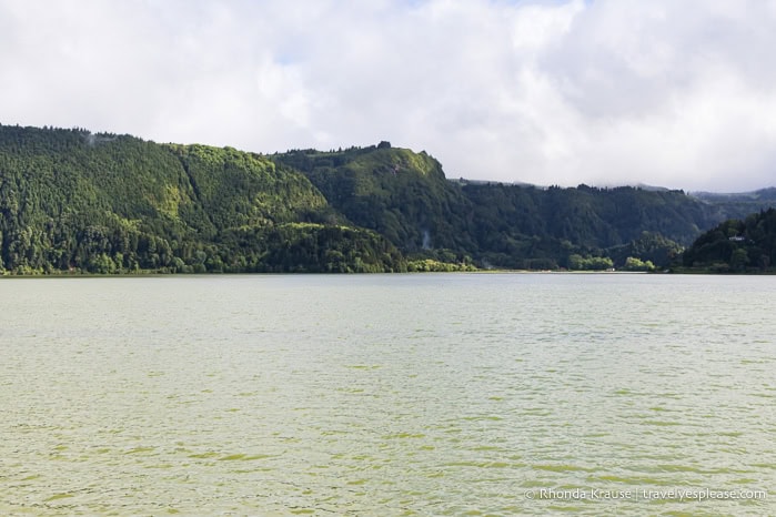
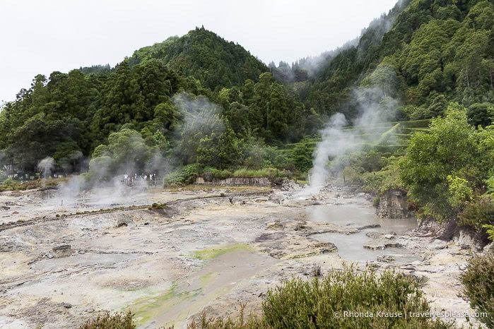
Along the route are several attractions, including the José do Canto Forest garden (home to the Chapel of Nossa Senhora das Vitórias and Salto do Rosal waterfall), and the bubbling geysers and steaming fumaroles at the Furnas Lake Hot Springs. Perhaps the most unique thing about the hot springs is that the local stew is cooked here in pots underground.
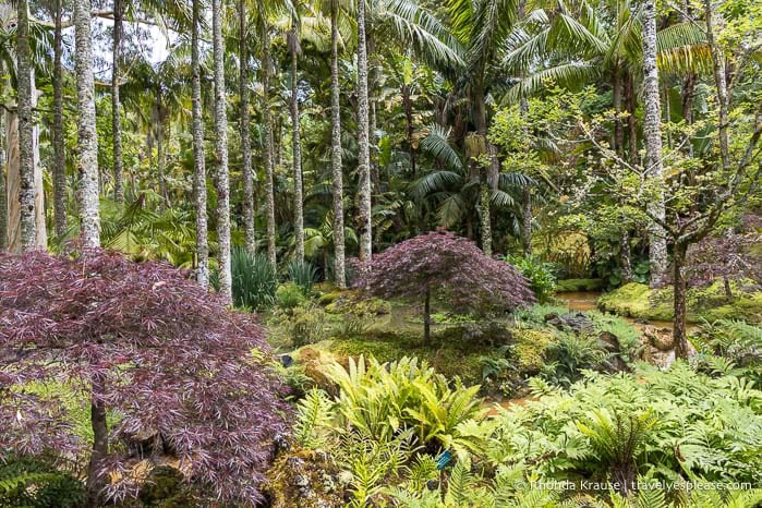
Terra Nostra Park
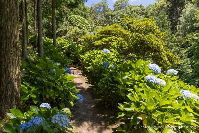
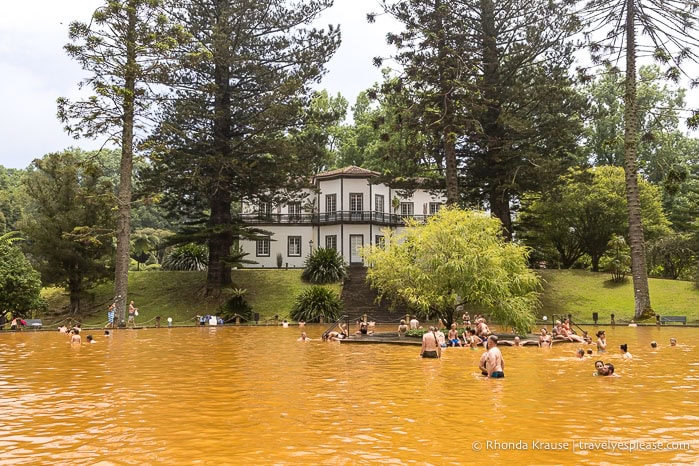
As a lover of gardens, I had to include Terra Nostra Park on my Azores itinerary. I happily lost track of time in this 200+ year old botanical park, roaming the sprawling grounds past exotic plants, streams, ponds, and grottos. The park’s most prominent feature is an iron-rich thermal pool, famous for its rust-coloured water.
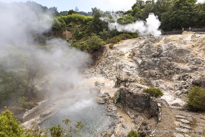
Caldeiras Square
Caldeiras Square (Largo das Caldeiras) is another spot where you can see steam rising from geysers and fumaroles. I thought the geysers here were better than the ones at Furnas Lake.
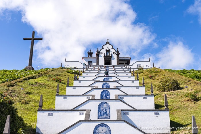
Nossa Senhora da Paz Chapel
A great photo stop on the way back to Ponta Delgada is Miradouro da Nossa Senhora da Paz, near Vila Franco do Campo.
The lookout offers views of Vila Fanca do Campo Islet, the crater of an underwater volcano with a perfectly round lagoon. On a hillside behind the viewpoint, a staircase leads up to the 18th century Nossa Senhora da Paz Chapel.
Day 20: Serra Devassa Hike, Ribeira dos Caldeirões Natural Park, Miradouro da Ponta do Sossego
I returned to the Sete Cidades area to hike the Serra Devassa trail and revisit Grota do Inferno viewpoint, since both are accessed from the same parking lot. After my hike, I drove to the east end of the island, stopping to visit Ribeira dos Caldeirões Natural Park and Miradouro da Ponta do Sossego. I returned to Ponta Delgada on the EN1-1A, which wasn’t the fastest route, but very scenic.
Serra Devassa Hike
I did so many incredible hikes in the Azores and the Serra Devassa trail was one of my favourites because of the lagoons and viewpoints.
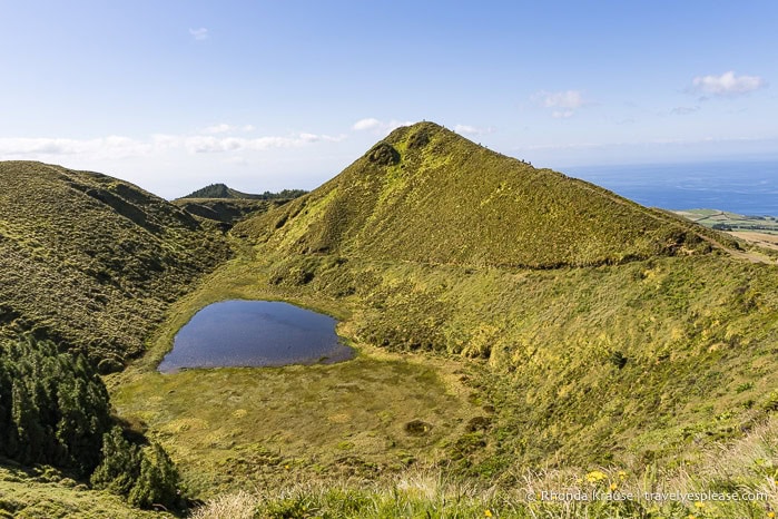
I chose to do a shorter circular route than the official PRC05 SMI, but still got to see all the main highlights. I especially loved the view from Pico da Éguas, the highest point on the trail, and the Empadadas Lagoons. A short detour on a hydrangea-framed trail to Miradouro do Pico do Paul was lovely as well.
Ribeira dos Caldeirões Natural Park
Parque Natural da Ribeira dos Caldeirões is a pretty park tucked into a lush valley. There are a couple of waterfalls, some historic watermills, walking trails, and tourist services like a gift shop, snack bar, and accommodation. There are also canyoning tours that operate here (I did one the next day).
Miradouro da Ponta do Sossego
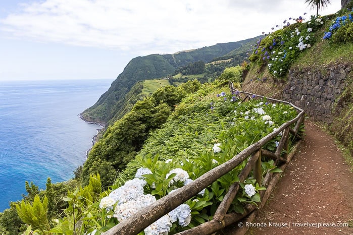
Way on the east coast of São Miguel is a gorgeous little roadside garden and viewpoint. A path through the manicured garden leads to a viewpoint and picnic area looking out to the ocean and steep cliffs covered in plants. Especially photogenic is the short trail just below the lookout point. I wished it were longer!
Day 21: Teófilo and Gruta Waterfalls Hike, Canyoning Tour
For my last full day on São Miguel, I returned to the northeast part of the island to hike a short trail that had two waterfalls. I then went on a canyoning tour at Ribeira dos Caldeirões Natural Park, which was nearby.
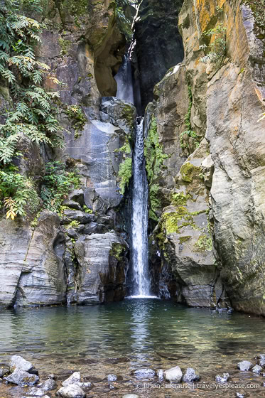
Cascata do Teófilo and Cascata da Gruta
The trail to reach the Teófilo and Gruta waterfalls starts near the parish of Lomba de São Pedro and is part of the Moinho do Felix loop hike (TM06).
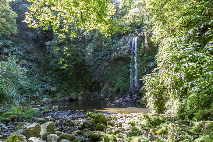
Gruta waterfall is the prettier of the two and has a little “cave” where you can stand behind the waterfall. Near Teófilo waterfall is the ruined Felix watermill. These waterfalls aren’t on the radar of most tourists, so I happily had them all to myself. It was a perfect place to sit and reflect on my 3 weeks in the Azores.
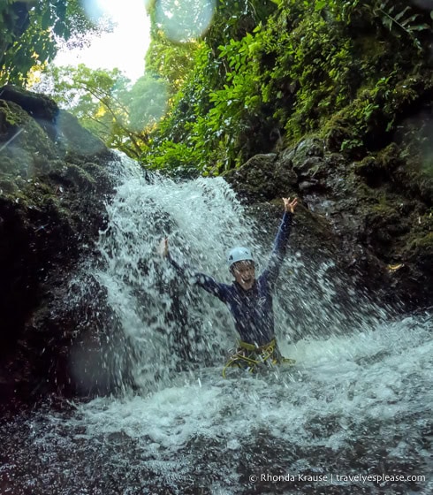
Canyoning Tour
I really wanted to try canyoning for the first time during my trip to the Azores. The two main spots for canyoning tours on São Miguel are Ribeira dos Caldeirões and Salto do Cabrito (my first choice, but it was sold out).
My canyoning tour at Ribeira dos Caldeirões was a wet and wild experience, thrilling enough for an adventurous beginner. I rappelled down a cliff face, jumped over ledges, and slid down natural waterslides. It was so much fun and I would love to do it again!
Day 22 (AM): Tour of Gruta do Carvão
My flight home departed late afternoon, so I had time to take a tour of Gruta do Carvão, which is conveniently located on the western edge of Ponta Delgada near the airport.
Gruta do Carvão
Gruta do Carvão is the largest lava tube on São Miguel, extending unobstructed for 1912 m/6273 ft. The cave can only be visited with a guide on a short or long tour.
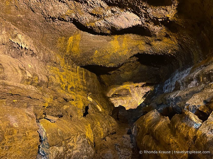
During the short tour, I got to see about 200 m/656 ft of the cave. My favourite part was all the smooth, cone-shaped stalactites on the ceiling. It wasn’t the best cave I visited during my 3 weeks in the Azores, but I still enjoyed it.
São Miguel Hits and Misses
Hits:
- The hikes and viewpoints in the Sete Cidades area. I couldn’t believe how lucky I was to have the Grota do Inferno viewpoint all to myself!
- The tropical setting of the Caldeira Velha thermal pools.
- So many beautiful waterfalls, parks, and gardens.
Misses:
- There were a lot more tourists than on other islands, so many of the attractions were busy and crowded.
- Ponta Delgada is not very interesting and having to pay for parking was annoying. It was my least favourite place on my Azores itinerary.
- Not seeing Fogo Lake because of cloud cover.
Final Thoughts About My Three Weeks in the Azores
I had so much fun on my Azores island-hopping trip and am glad I took 3 weeks to explore the archipelago in depth. The scenery was stunning, the hikes were rewarding, and the volcanic attractions were intriguing.
The islands were also easy to navigate as an independent traveller, once I had the transportation between islands organized, and I always felt safe travelling solo.
One of the things I loved about the Azores is that it’s still relatively unknown. When I told friends about my plans to visit the Azores, nobody had even heard of it. Mass tourism hasn’t reached the archipelago, other than São Miguel, but even there, it didn’t feel suffocating and the crowds could be avoided.
The Azores gave me plenty of opportunities to unwind and reconnect with myself, especially while exploring nature, which is why it was such a dream destination for someone like me who enjoys a lot of alone time.
The only thing that disappointed me was the fog covering so many places I wanted to see, especially on Flores Island. I planned for some extra days in my Azores itinerary in case of bad weather, but I wasn’t expecting fog to be such a persistent issue. Oh well, it gives me an excuse to go back one day, not that I need one since I had an incredible time!
Would I Change Anything About My Azores Itinerary?
I was very happy with my Azores trip itinerary and would only make a few minor changes.
I think I would have preferred starting my trip on São Miguel instead of Flores, since it was a long day travelling from Edmonton to Toronto to São Miguel to Flores. I began my trip very sleep deprived! I also would not have stayed in Ponta Delgada on São Miguel, just because I didn’t like the city.
The time I allocated to each island was perfect for my interests. If I had to shorten the trip, I would remove one day from Graciosa. If I had more time to spend, I’d add one day to Terceira to hike the Misterios Negros Trail.
Other than that, I thought my Azores itinerary included the best of what the islands have to offer- top attractions alongside some lesser-known gems. Having 3 weeks in the Azores was perfect because it gave me plenty of time to explore without having to rush, plus some flex days in case of bad weather.
Tips for Planning an Azores Itinerary
Here are a few tips to consider when planning your Azores trip itinerary:
- Book your car rental and accommodations way in advance for the smaller islands, especially Flores. I booked my trip 6 months ahead and had one option for where to stay in Flores, and it wasn’t very good.
- São Miguel and Terceira are the only two islands that receive international flights, with most arriving at São Miguel.
- For transportation between islands, there are flights on small prop planes and ferries. It’s generally best to fly between islands except for the “triangle” of Pico, Faial, and São Jorge. There are year-round, frequent ferries between the triangle islands and other islands have seasonal ferries (May-September, weather dependent).
- The best way to get around the Azores is by rental car. Bus service is limited and designed for locals. Taxis are available and even offer organized tours and drop-offs/pickups at hiking trails.
- Rental cars can be picked up at airports and ferry terminals. There is a small fee for picking up at one location and returning to another. I did this when I arrived by ferry but was leaving by plane (and vice versa) because it was more convenient. Allow some time in your itinerary for the rental car process because it’s usually not quick.
- I was able to reserve an automatic transmission car on every island except Corvo, where there are no car rentals.
- For inter-island flights, check-in opens 1.5 hours before the flight, so there’s no need to arrive way ahead of time. The airports are small with limited services.
- The weather is very changeable, and in my experience, the forecast wasn’t accurate. Add some extra days onto your itinerary to account for bad weather/fog on islands where you have “must-see” places.
- Some attractions must be pre-booked online, like the Caldeira Velha Thermal Pools and Poca da Dona Beija Hot Springs on São Miguel.
- Bring a debit card and have cash available because some gas stations don’t accept foreign credit cards like Visa and Mastercard.
- There are plenty of free natural attractions and outdoor activities if your budget is tight.

Accommodations in the Azores
For your convenience, here is a list of hotels in the Azores. Please consider booking your Azores accommodations through the included link. It costs nothing extra and helps support this website. Thank you!
Tours and Activities in the Azores
Here is a trusted site that has a large selection of tours and tickets for activities in the Azores. You can book everything from day trips, whale watching, adventure activities, and more. Here are a few related to what I mentioned in this post:
Digital SIM Cards (eSIM)
Airalo is an eSIM store/app where you can buy an affordable digital SIM card for your mobile phone. An eSIM lets you access a local data plan for your destination, so you don’t incur expensive roaming fees or always have to look for free Wi-Fi. I like how I can choose an eSIM by country or region and have it installed before leaving home (when my flight lands all I have to do is turn on the local line).